

Wikimedia Commons / CC-BY-SA-3.0 / GFDL
Capital: Ulaanbaatar
Population: 3.5 million+
Language: Mongolian

1 – Gorkhi-Terelj National Park (also above)

Gorkhi-Terelj starts about seventy kilometres northeast of Ulaanbaatar and is the national park most Mongolians and most visitors actually reach — a valley of granite outcrops, larch forest and open pasture along the southern edge of the Khentii mountains, with ger camps strung out along the river.
The landmark at Gorkhi-Terelj is Melkhii Khad, Turtle Rock, a twenty-metre granite boulder that really does look like a turtle; above it the Aryabal meditation temple is reached by a long flight of steps. Families hire out horses by the hour, and in winter the river freezes hard enough to walk on.
Behind Gorkhi-Terelj the Khentii range runs north, and somewhere in it stands Burkhan Khaldun — the mountain the Secret History of the Mongols says Genghis Khan hid on as a young man, worshipped afterwards, and was buried near. UNESCO listed it in 2015. Nobody has ever found the grave, and Mongolian law makes looking for it deliberately difficult.
2 – Gobi Gurvansaikhan National Park


Gobi Gurvansaikhan is Mongolia’s largest national park, some 27,000 square kilometres of the southern Gobi, named for the Three Beauties — the three ridges of the Gobi Altai that run through it. Gravel plain and bare rock make up most of it; less than a twentieth of the Gobi is sand at all. The sand that does exist is worth the drive.
Khongoryn Els runs for around a hundred kilometres with dunes reaching three hundred metres, and they hum when the face slides. Bactrian camels graze the saxaul scrub, and herding families still work inside the park — around a hundred and sixty thousand people live in this province.
Gobi Gurvansaikhan holds the mazaalai, the Gobi bear: the only bear on earth that lives in true desert, and among the rarest large mammals anywhere. Recent counts put the entire wild population somewhere between about thirty and fifty animals, all of them in this one corner of the Gobi, and they are fed at supplementary stations in spring because there is not reliably enough for them to eat.
3 – Genghis Khan Equestrian Statue – Töv Province

The Genghis Khan Equestrian Statue stands on the bank of the Tuul river at Tsonjin Boldog, about fifty kilometres east of Ulaanbaatar. It is forty metres of stainless steel on a ten-metre base, some two hundred and fifty tonnes of it, and it was finished in 2008 for the eight hundredth anniversary of the founding of the Mongol Empire.
Thirty-six columns ring the base of the statue, one for each khan from Genghis to Ligdan. You go up inside through the horse’s chest and out onto its head, level with the back of Genghis’s own. There is a museum underneath, and local tradition holds that this is the spot where he found a golden whip. For most of the twentieth century a monument like this was unthinkable.
Under the Mongolian People’s Republic Genghis Khan was close to unmentionable, and when the 800th anniversary of his birth was marked in 1962 senior officials were purged for nationalism under Soviet pressure. Since 1990 the rehabilitation has been total: he is on the banknotes, the airport, the vodka and the beer.
4 – Flaming Cliffs

The Flaming Cliffs are a wall of red sandstone at Bayanzag in the southern Gobi, within the Gurvansaikhan park area, which turn orange and then deep red as the sun goes down. The Mongolian name means “rich in saxaul”, after the scrub around them; the English one was coined by an American who camped beneath them in the 1920s.
That was Roy Chapman Andrews, who took the American Museum of Natural History’s Central Asiatic Expeditions across the Gobi by motor car. Fossil bone still weathers out of the cliffs at Bayanzag and lies about in fragments on the ground — and Mongolian law prohibits picking any of it up.
In July 1923 Andrews’s team found something at the Flaming Cliffs that nobody had confirmed before: a clutch of fossilised dinosaur eggs. Until then it was not established that dinosaurs laid eggs at all. The same expeditions turned up Velociraptor, Protoceratops and Oviraptor — the last of which was named for apparently stealing eggs, and was much later found to have been sitting on its own.
5 – Yolyn Am

Yolyn Am is a gorge cut deep into the Zuun Saikhan ridge inside Gobi Gurvansaikhan National Park, and its name means the lammergeier’s mouth — bearded vultures nest on the walls, along with Himalayan and cinereous vultures. In places the rock faces close to a few metres apart.
You walk into Yolyn Am along a stream from the small museum at the entrance, a couple of hours up and back, between walls a couple of hundred metres high. Ibex work the slopes above and pikas live in the scree. It runs several degrees colder in the gorge than out on the plain thirty kilometres away. There is ice on the floor of Yolyn Am, in the middle of a desert.
The gorge is so narrow and so deep that sunlight barely reaches the bottom, so the winter stream freezes into a field several metres thick and kilometres long. It used to last the whole year round. It does not any more — in most years now it is gone by September.
6 – Erdene Zuu Monastery

Erdene Zuu was built in 1585 by Abtai Sain Khan, just outside the ruins of Karakorum — the capital Genghis Khan’s son Ögedei founded in the 1230s and the Ming razed in 1388. The monastery went up using stone carted out of those ruins, and it is the oldest surviving Buddhist monastery in Mongolia. A square wall roughly four hundred metres a side is topped with stupas — a hundred and eight was the intention, for the beads of a Buddhist rosary, though whether that number was ever reached is doubtful.
Inside Erdene Zuu are three Chinese-roofed temples from the founding period, a later Tibetan-style temple, and the stupas holding Abtai Khan and his son. UNESCO listed the site in 2004 as part of the Orkhon Valley. At its height Erdene Zuu had somewhere between sixty and a hundred temples and around a thousand monks.
In 1937 and 1938 the Mongolian government destroyed the monasteries of the entire country — several hundred of them — and killed monks in the tens of thousands. Three temples and the wall survived here. The site reopened in 1965 as a museum, and only became a working monastery again in 1990.
7 – Ulaanbaatar
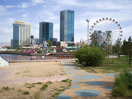
Ulaanbaatar holds around 1.6 million people — close to half of Mongolia’s entire population — in a valley on the Tuul river at about 1,350 metres. Its mean annual temperature sits a little below freezing, which makes Ulaanbaatar the coldest capital city in the world.
Gandantegchinlen is the working monastery at the centre of the city, with a 26-metre gilded Migjid Janraisig standing inside it; the original was carted off by Soviet troops in 1938 and the present figure was built in 1996. There is also Sükhbaatar Square, the Chinggis Khaan National Museum, the Bogd Khan’s winter palace, and ger districts climbing the hills around the edges.
Ulaanbaatar used to be a nomadic city. Founded in 1639 as a movable monastery called Örgöö, it packed up and shifted somewhere between twenty-five and twenty-nine times over the next century and a half, following pasture and politics along the Tuul and Orkhon rivers. It settled at its present site only in 1778, and took its current name — Red Hero — only in 1924.
8 – Khövsgöl Lake
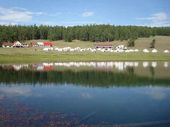
Khövsgöl is 136 kilometres long, 262 metres deep, and sits at 1,645 metres against the Russian border, where the Central Asian steppe runs into the Siberian taiga. It is somewhere between two and five million years old, one of only seventeen ancient lakes in the world, and it holds close to seventy per cent of all the fresh water in Mongolia.
The water in Khövsgöl is drinkable straight out of the lake and clear to more than twenty metres down. Khatgal at the southern end is the base; you ride, walk or drive the shore through the summer, and from late November it freezes to a metre thick. The Tsaatan, among the last reindeer herders anywhere, live in the taiga several days’ ride west of it.
Khövsgöl drains north into Lake Baikal, and it takes a long way round to get there. The Eg river leaves the southern end, joins the Selenge, and the water travels more than a thousand kilometres and drops nearly twelve hundred metres before it arrives — to cover a straight-line distance of about two hundred.
9 – Altai Tavan Bogd National Park
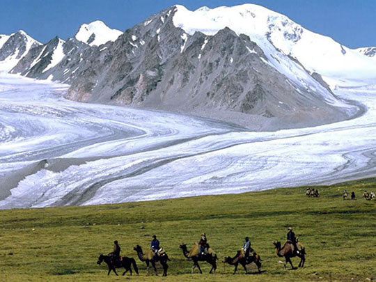

Altai Tavan Bogd lies in Bayan-Ölgii, the far western province, and takes its name from the Five Saints — the massif on the frontier where Mongolia, Russia and China meet. Khüiten Peak, at 4,374 metres, is the highest point in the country, and the Potanin glacier running below it is Mongolia’s longest.
Below the ice, Altai Tavan Bogd holds the Khoton, Khurgan and Dayan lakes and a long valley of summer pasture. The rocks along the Tsagaan Salaa and Baga Oigor valleys carry tens of thousands of petroglyphs cut over roughly twelve thousand years, from Stone Age hunters to Turkic horsemen, and UNESCO listed them in 2011.
Bayan-Ölgii is the only province in Mongolia without a Mongol majority — around nine in ten people here are Kazakh — and it is where golden eagle hunting survives. Birds are taken as chicks, worked with for several winters, and then, by the tradition, released back into the mountains to breed. There is a festival at Ölgii each October, but the hunting itself is a working practice rather than a display.