

Wikimedia Commons / CC-BY-SA-3.0 / GFDL
Capital: Banjul
Population: 2.4 million+
Language: English, Mandinka, Pulaar, Wolof

1 – Gambia River (also above)

The Gambia River winds some 1,120 km from the Fouta Djallon highlands of Guinea through Senegal to the Atlantic at Banjul, and it is one of West Africa’s most navigable rivers, with ocean-going ships able to sail about 240 km upstream to Kuntaur.
Broad, tidal and fringed with mangroves, the Gambia River is the nation’s great highway, its banks home to fishing villages, hippos and crocodiles, while critically endangered Atlantic humpback dolphins are sometimes seen near the estuary.
The Gambia exists because of its river, for the 1889 Anglo-French agreement set the border about 10 km either side of it, creating mainland Africa’s smallest country, though the popular story that the line was fixed by the range of a cannon is a legend.
2 – Wassu Stone Circles
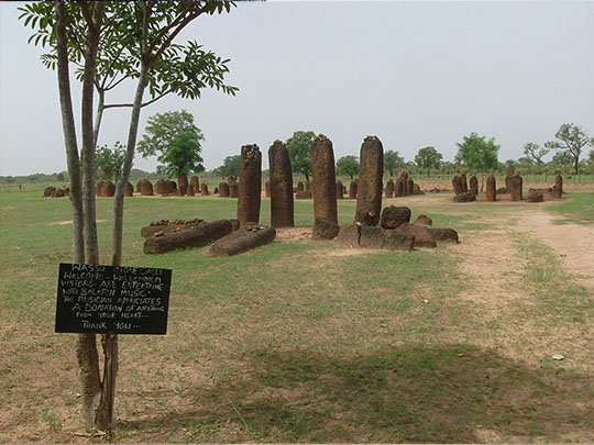

Wassu, in the Central River Region, is one of four great clusters of the Senegambian stone circles, more than 1,000 monuments in a band 100 km wide along 350 km of the river, which UNESCO listed in 2006 as “an extraordinary concentration” of stone circles.
Rings of eight to fourteen laterite pillars, quarried and dressed with iron tools, stand about 2 m tall and weigh up to 7 tonnes around the burial mounds at Wassu, where a small museum explains what is known of their builders.
The tradition of raising the circles lasted from about the 3rd century BC to the 16th century AD, and the burials they mark, those at Wassu dated to around AD 927–1305, have yielded pottery, iron tools and ornaments.
3 – Kunta Kinteh Island

Kunta Kinteh Island, a speck of ruins in the Gambia River, was fortified by the Duchy of Courland in 1651 and later held by the Dutch, English and French, becoming a trading fort and a holding point for enslaved Africans before shipment.
Renamed James Island by the English, who took it in 1661, the island has shrunk to a fraction of its former size, yet the ruins of Fort James survive, part of a UNESCO World Heritage Site listed in 2003 with the riverside villages of Juffureh and Albreda.
In 2011 the island was renamed after Kunta Kinte, the hero of Alex Haley’s Roots, who in the book is taken from near Juffureh and shipped to Maryland in 1767, a story that made this stretch of river a place of pilgrimage for the African diaspora.
4 – Kiang West National Park

Kiang West National Park, set up in 1987 on the south bank of the Gambia River, is one of the country’s largest and most important wildlife reserves, a wild expanse of dry woodland, savanna and mangrove creek.
Explore Kiang West by 4×4 and by boat, scanning for warthog and Guinea baboons, with spotted hyena and rarely seen leopard about, from viewpoints such as Tubabkollon Point, while more than 300 kinds of bird make it a birder’s dream.
Hidden in Kiang West’s mangrove creeks lives the West African manatee, a shy “sea cow” that grazes the shallows, the kind of creature long linked with sailors’ tales of mermaids.
5 – Banjul
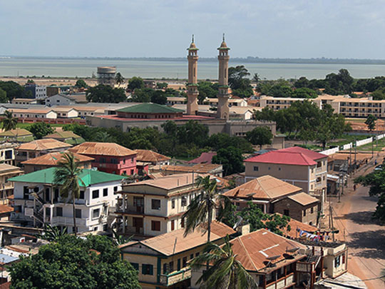

Banjul, on St Mary’s Island at the mouth of the Gambia River, was founded by the British in 1816 as Bathurst, a base against the newly illegal slave trade and for British merchants, and took the name Banjul in 1973.
Arch 22, a 35 m gateway marking the 1994 coup that brought Yahya Jammeh to power, straddles the road into Banjul, a city whose Catholic diocese was led for half a century by Irish Holy Ghost Fathers, from Michael Moloney of County Clare, first Bishop of Bathurst in 1957, to Michael Cleary of County Mayo.
In January 1943 Franklin Roosevelt passed through Bathurst on his way to and from the Casablanca Conference and, appalled by the poverty, later called it “that hell-hole of yours” in a letter to Churchill.
6 – Kotu and Kololi
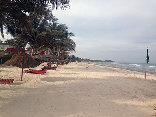
Kotu and Kololi, a few kilometres down the coast from Banjul, form the heart of the tourist industry on the “Smiling Coast of Africa”, which by government estimates makes up roughly a fifth of The Gambia’s economy.
Kotu has wide open sand and beach bars, while Kololi has the Senegambia strip of hotels, restaurants and craft stalls, and along the shore pirogues are hauled up on the sand.
The story goes that the Swedish traveller Bertil Harding came upon The Gambia by chance in 1965, and with the tour operator Vingresor he soon brought the first Scandinavian package tourists to its beaches.
7 – Abuko Nature Reserve

Abuko Nature Reserve, a pocket of gallery forest along the Lamin Stream south of Banjul, was first protected in 1916 when its catchment was fenced as a water supply, and became The Gambia’s first nature reserve in 1968.
A shady forest loop at Abuko brings visitors close to red colobus and green monkeys, crocodiles basking at the stream pools, and enclosures caring for rescued animals.
For all its 107 ha, Abuko is home to more than 270 species of bird and to both Nile and dwarf crocodiles.