

Wikimedia Commons / CC-BY-SA-3.0 / GFDL
Capital: Andorra la Vella
Population: 89,000+
Language: Catalan

1 – Andorra la Vella (also above)

Andorra la Vella sits at about 1,023 m in the Gran Valira valley, usually ranked the highest capital in Europe, and runs a co-principality that goes back to the paréages of 1278 and 1288 between the Bishop of Urgell and the Count of Foix, whose rights ended up with the French head of state.
See the Casa de la Vall, built in 1580 as a fortified family house and home to Andorra’s parliament until 2011, with its cabinet of seven keys, plus Romanesque Sant Esteve, pre-Romanesque Santa Coloma with its round bell tower, Dalí’s melting-clock bronze, The Nobility of Time, and the Estadi Nacional.
Andorra la Vella never had to make peace with Germany, as the story that Andorra declared war in 1914 and stayed at war until 1958 is a myth: no declaration has ever been found, and the tale first appeared in American newspapers in 1958.
2 – La Massana

La Massana is Andorra’s north-western parish, bordering both France and Spain, and takes in the villages of Arinsal, Pal, Xixerella, Erts and Sispony.
Don’t miss Romanesque Sant Climent de Pal, whose Lombard bell tower has double twin windows found nowhere else in Andorra, the Comapedrosa Natural Park around Andorra’s highest peak at 2,942 m, and the 19th-century Farga Rossell forge, which tells the story of Andorra’s iron industry.
La Massana’s Vedat de Xixerella is officially a “vedat de caça”, or hunting reserve, but the 2000 law that created it bans hunting there outright to protect wildlife.
3 – Arinsal

Arinsal is a village in La Massana parish at about 1,470 m, the last settlement up its valley on an old route over the Arinsal pass to France’s Vicdessos valley.
Look for Sant Andreu d’Arinsal, a 17th-century church built straight onto the bedrock without foundations, then head for the ski slopes rising to about 2,560 m or the trail that makes Arinsal the usual starting point for climbing Andorra’s highest summit.
Arinsal feels like the top of Andorra, but it isn’t the country’s highest village, as Pas de la Casa on the French border sits about 600 m higher.
4 – Sant Julià de Lòria

Sant Julià de Lòria is Andorra’s southernmost parish, where the main road crosses into Spain near the country’s lowest point of around 840 m, and its Reig tobacco factory ran from 1909 until 1957.
See the Lombard Romanesque bell tower of Sant Julià i Sant Germà, the 11th-century chapel of Sant Serni de Nagol, the Sanctuary of Canòlich, where pilgrims share blessed bread on the last Saturday of May, Andorra’s only university, and the 5.3 km Tobotronc at La Rabassa, one of the longest toboggan runs around.
Sant Julià de Lòria’s football club is UE Sant Julià.
5 – Grandvalira Ski Resort

Grandvalira stretches across the parishes of Encamp and Canillo from Pas de la Casa on the French border to Soldeu and El Tarter, and was formed in 2003 when the Pas de la Casa–Grau Roig and Soldeu–El Tarter ski areas merged.
Billed as the biggest ski area in the Pyrenees, Grandvalira tops out at Pic Blanc, about 2,640 m, sits beside the 2,408 m Port d’Envalira, often cited as the highest paved road pass in the Pyrenees, and hosted the 2019 Alpine Ski World Cup Finals on Soldeu’s runs.
On the 1964 Tour de France, Jacques Anquetil spent the rest day in Andorra feasting on a lamb barbecue and nearly lost the race climbing the Envalira next morning, and accounts disagree on whether the drink that revived him was champagne or whisky.
6 – Madriu-Perafita-Claror Valley
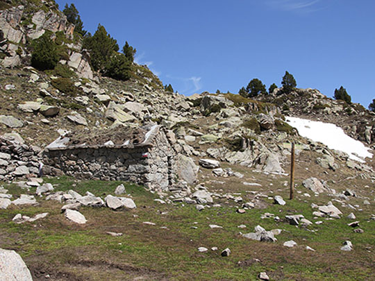
The Madriu-Perafita-Claror Valley is a glacial valley in south-east Andorra running up to the Spanish border, covering roughly a tenth of the country, and its land has been held in common for over 700 years, which helped make it Andorra’s first UNESCO World Heritage Site in 2004.
Walk in from the Engolasters road to the stone-roofed summer hamlets of Entremesaigües and Ramio, past old terraced fields, shepherds’ huts and the riverside Farga del Madriu iron forge, keeping an eye out for chamois and bearded vultures overhead.
The Madriu valley is often described as Andorra’s last roadless valley, so the only way in is on foot, along stone-paved tracks that once linked it with Catalonia and France.
7 – Sanctuary of Meritxell
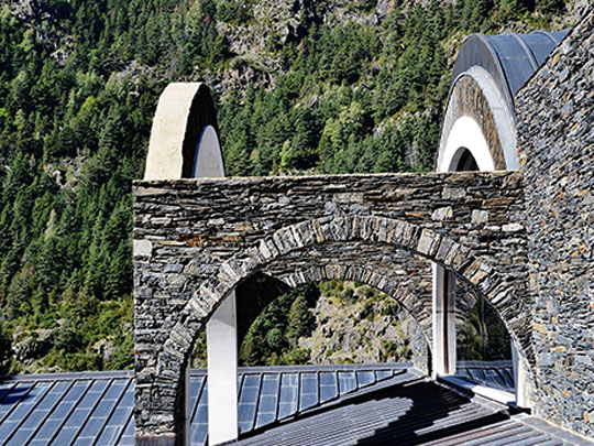
The Sanctuary of Meritxell, in Canillo parish, honours Our Lady of Meritxell, declared Andorra’s patron in 1873, whose feast day on 8 September is National Day, and on the night of 8–9 September 1972 fire gutted the old chapel and destroyed her 12th-century wooden statue.
Ricardo Bofill’s new Sanctuary of Meritxell opened on 8 September 1976, in slate and white stone around an open cloister of arches, with a replica statue by Sergi Mas based on photos of the lost original, and the restored 17th-century chapel next door.
According to legend, villagers found the Meritxell statue under a wild rose blooming out of season, and every time they carried it to the churches at Canillo or Encamp it returned to the rose, so they built the chapel on that spot.