
Wikimedia Commons / CC-BY-SA-3.0 / GFDL
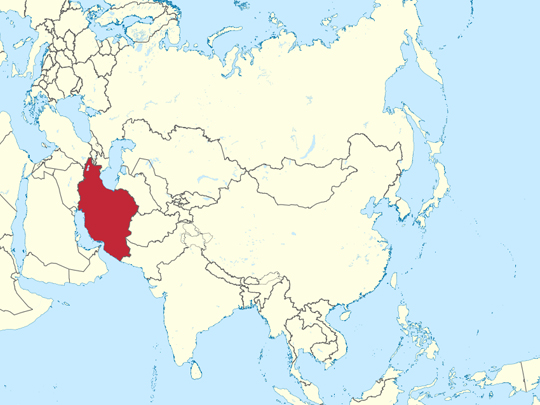
Capital: Tehran
Population: 90 million+
Language: Persian/Azerbaijani
1 – Naqsh-e Rustam (also above)
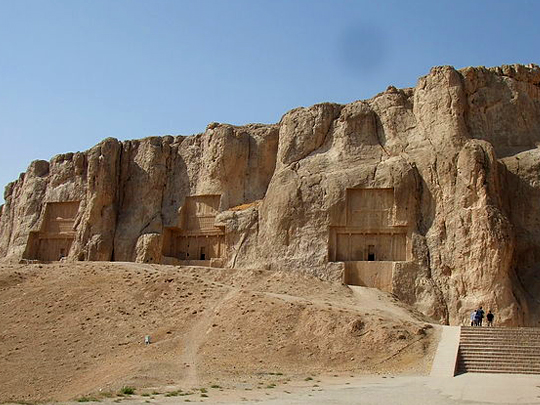
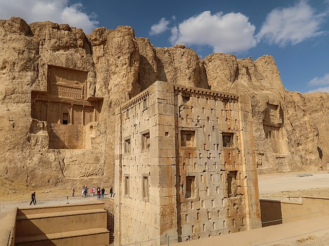
Naqsh-e Rustam is a cliff face six kilometres north of Persepolis in Fars province, cut with four Achaemenid royal tombs set high in the rock in the shape of crosses — one of them certainly that of Darius the Great, who died in 486 BC, the other three generally attributed to Xerxes I, Artaxerxes I and Darius II.
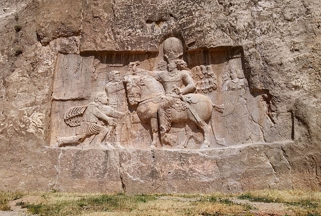
Below the tombs at Naqsh-e Rustam are eight Sassanian reliefs carved some seven hundred years later, and in front of them stands the Ka’ba-ye Zartosht, a square stone tower whose purpose is still argued over — fire temple, treasury or royal archive — carrying a long trilingual inscription of Shapur I across its walls.
The best of those reliefs shows Shapur I on horseback with two Roman emperors in front of him. The standing figure whose wrist he holds is generally identified as Valerian, captured at Edessa in 260 and the only Roman emperor ever taken alive by an enemy; the kneeling one is usually read as Philip the Arab. Naqsh-e Rustam is where a Persian king had that cut into a cliff and left it.
2 – Persepolis
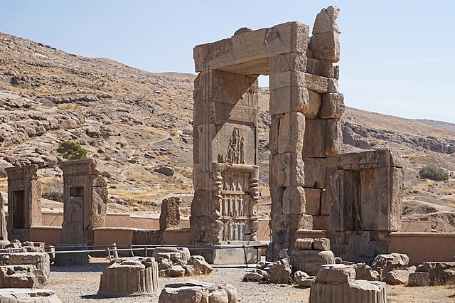
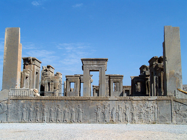
Persepolis was begun around 518 BC by Darius the Great as the ceremonial capital of the Achaemenid empire — not a city anyone lived in but a stage for receiving the empire, raised on an enormous stone terrace against a mountainside in Fars and used mainly at Nowruz, the spring new year.
You climb the double staircase at Persepolis and pass through the Gate of All Nations with its winged bulls; beyond lie the Apadana audience hall, the Hundred-Column Hall, the Tachara palace of Darius and the treasury. The columns still standing are a small fraction of what once stood.
The thing to find at Persepolis is the Apadana staircase, carved with twenty-three delegations bringing tribute — Ethiopians, Indians with gold, Armenians leading a horse, Lydians, Bactrians, Arabs with a camel — each in its own dress and each identifiable. It is an empire drawing a picture of itself. Alexander burned the place in 330 BC, and the fire is partly why the reliefs survive: collapsing roofs buried them.
3 – Chogha Zanbil
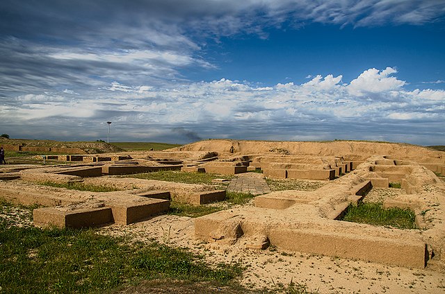
Chogha Zanbil is an Elamite ziggurat on the Khuzestan plain near Susa, built around 1250 BC by King Untash-Napirisha at the centre of a sacred city called Dur Untash — and it is the oldest large monument still standing anywhere in Iran, older than Persepolis by some seven hundred years.
The ziggurat at Chogha Zanbil rose five storeys and about fifty metres; roughly twenty-five metres survive, on a square base a hundred metres to a side, built from millions of mud bricks with inscribed bands running round them. Three concentric walls enclose temples, palaces and vaulted royal tombs, and almost nobody but priests ever lived inside them.
Chogha Zanbil is the best-preserved ziggurat anywhere on earth, including Iraq — and nobody knew it was there. It lay under wind-blown sediment for two and a half thousand years until 1935, when an aircraft surveying Khuzestan for the Anglo-Iranian Oil Company photographed an odd rectangular mound on an empty plain. It became Iran’s first UNESCO World Heritage Site in 1979.
4 – Imam Square
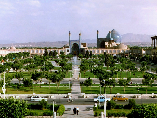
Imam Square in Isfahan — also known as Naqsh-e Jahan, the image of the world, which is the older name, and listed by UNESCO as Meidan Emam — was laid out between 1598 and 1629 by Shah Abbas I when he moved the Safavid capital here. At 160 metres by roughly 520 it remains among the largest squares on earth.
Each side of Imam Square holds one building: the Shah Mosque at the southern end under its twisting blue tilework, the small Sheikh Lotfollah Mosque facing it, built as a private royal chapel with no minarets and no courtyard, the Ali Qapu palace on the west with its carved music room, and the gate into the covered bazaar at the north.
Shah Abbas used Imam Square as a polo ground, and the stone goalposts he played between are still standing at either end, several hundred metres apart. They are the one feature of the square that almost every visitor walks straight past.
5 – Amir Chakhmaq Complex
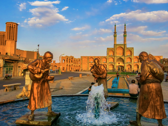
The Amir Chakhmaq Complex stands on a square in Yazd, in the desert of central Iran — a mosque founded in the 1430s by Amir Jalaleddin Chakhmaq, a Timurid governor of the city, and his wife Bibi Fatemeh, with a caravanserai, a bathhouse and a water cistern accumulating around it over the centuries since.
What everyone photographs at Amir Chakhmaq is the tekyeh: a three-storey facade of recessed alcoves rising in rows above the square between two minarets, floodlit after dark and reflected in the pool in front of it. Behind it the Yazd bazaar runs off into lanes of mud-brick houses topped with badgirs, the windcatchers that cool the city.
The tekyeh at Amir Chakhmaq is not really a building but a stage. It was raised for the Muharram mourning of Hussein, and at Ashura a nakhl — a vast wooden frame in the shape of a palm, weighing several tonnes — is lifted and carried around the square by hundreds of men at once. The alcoves are where the crowd stands to watch.
6 – Milad Tower
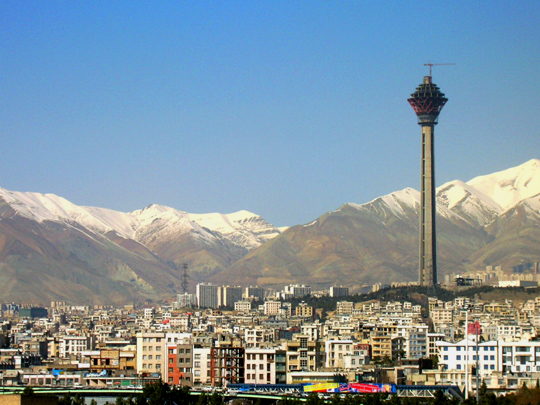
Bahador / Wikimedia Commons / CC-BY-SA-3.0 / GFDL
Milad Tower is a 435-metre concrete telecommunications tower in northwestern Tehran, completed in 2007 and for some years the tallest structure in Iran — which makes it the newest thing on this page by roughly thirteen hundred years. There is an observation deck and a revolving restaurant in the head of Milad Tower, and what you go up for is the city.
Tehran spreads out below — nine million people in the city proper and far more across the wider area — with the wall of the Alborz along the northern edge and Damavand, a 5,600-metre volcano, standing behind them on a clear winter morning. Milad Tower is the best place to understand how Tehran actually works.
The city climbs from about 1,100 metres in the south to 1,700 in the north, and it has sorted itself along that slope: cooler, cleaner air and money at the top, heat and traffic at the bottom. Tehran’s vertical axis is also its social one, and from up here you can see it.
7 – Azadi Tower – Tehran
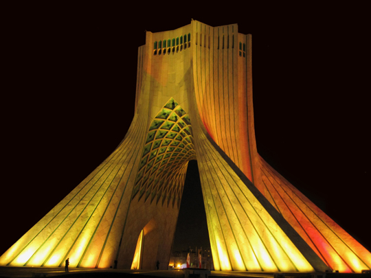
Azadi Tower stands on a plaza of 120,000 square metres at the western entrance to Tehran: forty-five metres of white Isfahan marble over a broken arch, built for the Shah’s celebrations of the 2,500th anniversary of the Persian Empire and opened in 1971 under the name Shahyad, the Shah’s memorial.
The form of Azadi Tower mixes periods deliberately — a Sassanian barrel vault at the base, muqarnas vaulting in the Islamic manner overhead, the whole thing faced in stone and set among fountains. There is a museum underneath it, and the interior is open to visitors. The design competition was won in 1966 by Hossein Amanat, then twenty-four and barely out of university.
After the 1979 revolution Azadi Tower was not demolished, as many expected, but renamed Azadi — freedom — and it has been the backdrop to every large public gathering since, including those against the government. Amanat, a Baháʼí, left Iran and has never returned.
8 – Rudkhan Castle
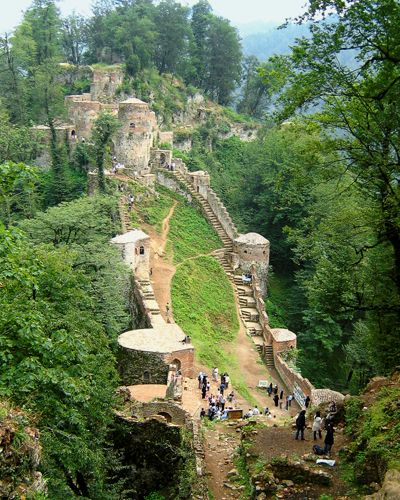
Rudkhan Castle sits astride two ridges above a forested valley near Fuman in Gilan province, on the Caspian side of the Alborz — Sassanid in origin, largely rebuilt under the Seljuks and later held by the Ismailis, with around sixty-five towers and a kilometre and a half of curtain wall. Getting to Rudkhan Castle is most of the point.
A path of roughly a thousand irregular stone steps climbs through dense forest beside a stream, taking most people well over an hour, and the castle appears in fragments through the trees rather than all at once. Inside are two gates, a bathhouse and cisterns. The forest Rudkhan Castle stands in is older than anything else on this page.
The Hyrcanian woodlands along the southern Caspian are a relic of the broadleaf forest that covered much of the northern hemisphere before the ice ages, surviving here because the Alborz sheltered them; UNESCO listed them in 2019. Iran is mostly arid, and this corner of it is temperate rainforest.
9 – Pasargadae
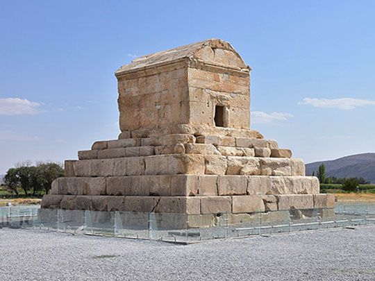

Pasargadae was the first capital of the Achaemenid empire, founded by Cyrus the Great around 546 BC on a plain in Fars some eighty kilometres northeast of Persepolis — a scatter of palaces, gatehouses, gardens and stone watercourses spread across a couple of square kilometres rather than any kind of dense city.
The building everyone comes to Pasargadae for is the tomb of Cyrus: a small gabled stone chamber on a plinth of six receding steps, standing alone in open ground and visible from every direction for miles. Around it are two ruined palaces, a gatehouse carrying a four-winged guardian figure in relief, and the earliest known Persian garden.
Alexander reached Pasargadae in 330 BC, found the tomb broken open and stripped, and ordered his officer Aristobulus to repair and reseal it. Twelve centuries later, tradition holds that locals saved it from the Arab conquest by insisting it was the tomb of the mother of Solomon — and the name stuck so thoroughly that it was still called that when Europeans identified the site in the 1800s.
10 – Shiraz
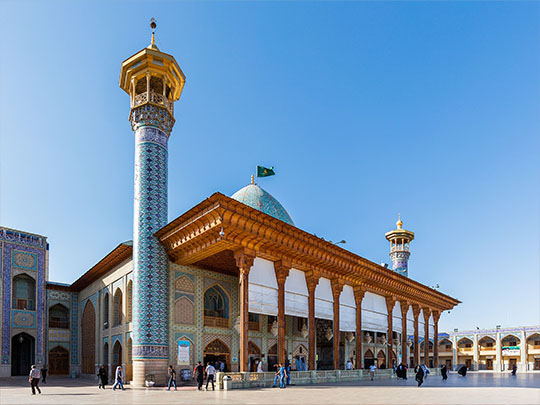
Shiraz lies in a valley in Fars about an hour south of Persepolis, and has been a centre of Persian arts and letters for eight hundred years — capital under the Zand dynasty from 1750, and the home city of Hafez and Saadi, the two poets Iranians quote most readily and know best by heart.
In Shiraz you go to the Nasir al-Mulk mosque, finished in 1888, whose winter prayer hall is glazed with coloured glass that throws the whole spectrum across the carpets for an hour after sunrise; to the Vakil bazaar and the Zand citadel; to the Eram garden, one of the nine UNESCO-listed Persian gardens; and to the poets’ tombs.
The tomb of Hafez, in its garden on the northern edge of Shiraz, is not really a monument. Iranians come to take a fal — ask a question, open the Divan at random, and read the poem they land on as the answer. Men with caged birds sit outside and let the bird pick your card. Fourteenth-century poetry, working as an oracle, daily.
11 – Zoroastrian Yazd
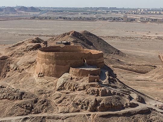
Yazd was a refuge. After the Arab conquest ended the Sassanian empire in the seventh century, this desert city held the largest surviving Zoroastrian community in Iran, and it still does — roughly twenty thousand of the ninety thousand or so Zoroastrians left in the country, out of perhaps two hundred thousand worldwide.
The Yazd Atash Behram, built in 1934, keeps its fire in a bronze vessel behind glass, fed dry wood several times a day; non-Zoroastrians can see it but not enter the sanctum. On the edge of Yazd two Towers of Silence stand on bare hills above the low buildings of the old funeral complex, unused since about the 1970s.
The fire in the Atash Behram at Yazd is said to have burned since around 470 AD. It was kindled in a temple in Larestan, carried to Aqda where it burned for some seven hundred years, then to Ardakan, then into a priest’s house in Yazd — hidden and moved for fifteen centuries so that it would not go out. The building it finally rests in was paid for by Parsis in Bombay.
12 – Dasht-e Lut
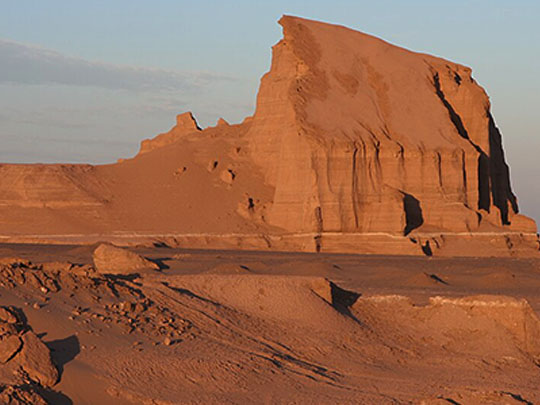
The Dasht-e Lut is a sand and rock desert covering some 50,000 square kilometres of southeastern Iran, empty enough to have essentially no permanent population at all — and in 2016 it became the first natural site anywhere in Iran to be inscribed by UNESCO.
What makes the Dasht-e Lut worth the drive is the kaluts: a corridor of wind-carved ridges running roughly eighty kilometres north to south, some of them 150 metres high, eroded into parallel walls and canyons by a wind that blows from the same direction for months at a time. Trips run out from Kerman and Shahdad.
The hottest surface temperature ever recorded on earth was measured over the Dasht-e Lut by satellite — around 70°C, with a later reanalysis putting it higher again. That is ground temperature, not air temperature; the air record belongs to Death Valley, and the two are confused constantly. The distinction is the point: this is where the ground gets hotter than anywhere else on the planet.
13 – Tabriz Bazaar
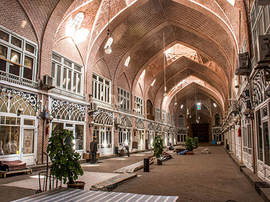

The Tabriz Bazaar is a roofed brick city in its own right in northwestern Iran, covering something like a square kilometre of vaulted halls, caravanserais, mosques and schools — the commercial heart of a city that was an Ilkhanid capital, briefly a Safavid one, and among the most important exchanges on the Silk Road. UNESCO listed it in 2010.
Inside the Tabriz Bazaar the trades are still grouped by hall: the Mozaffariyeh for carpets, others for gold, spices, shoes and copper, each under its own run of domed brick vaults with daylight dropping through openings in the ceiling. Tabriz is a mainly Azerbaijani-speaking city, and the bazaar is where you hear it.
The Tabriz Bazaar was never only a market. Its merchants funded and sheltered the Constitutional Revolution of 1905 to 1911, the movement that won Iran its first parliament and its first constitution, and when royalist forces besieged Tabriz in 1908 the bazaar was at the centre of the resistance. Iranian bazaars have been political institutions ever since.
14 – Susa
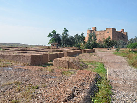
Susa, called Shush today, is one of the oldest continuously occupied places on earth — settled by around 4200 BC, capital of Elam, and later the administrative capital of the Achaemenid empire, where Darius built his palace and where the Book of Esther is set. Persepolis was the ceremonial capital; Susa is where the actual work of the empire was done.
UNESCO listed it in 2015. The mound at Susa holds the foundations of Darius’s palace and its Apadana. Below it stands the Tomb of Daniel under a white sugarloaf spire, still a working pilgrimage site, and up on the acropolis sits a French castle built in the 1890s to house the excavators — raised from bricks robbed out of the Apadana and out of Chogha Zanbil down the road, some of them still carrying cuneiform.
The Code of Hammurabi was dug out of Susa in three pieces in 1901. It had been carved in Babylon around 1750 BC and looted from Sippar by the Elamite king Shutruk-Nahhunte some six centuries later, and carried here as war booty. It is in the Louvre now, along with most of what came out of Susa.