
Wikimedia Commons / CC-BY-SA-3.0 / GFDL
Capital: Jerusalem
Population: 10 million+
Language: Hebrew (official), Arabic.
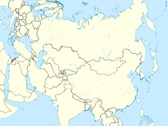
1 – Jerusalem – (also above)
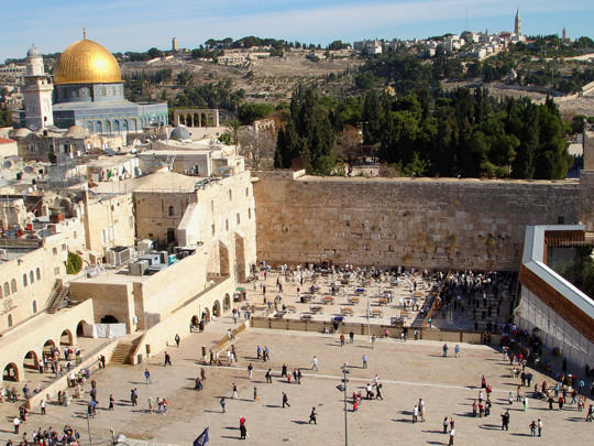
Western Wall
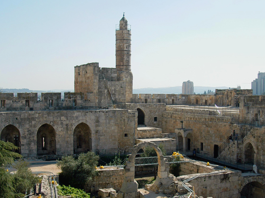
Tower of David
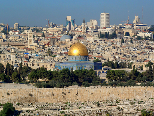
Jerusalem is the only city holy to Judaism, Christianity and Islam at once, and almost all of that is packed inside one walled square kilometre. The Old City, holding the Western Wall, the Temple Mount — the Haram al-Sharif — and the Church of the Holy Sepulchre, lies in East Jerusalem, which Israel took in 1967 and applied its law to; that annexation is not recognised by the United Nations or by most states.
The Western Wall is a retaining wall of the platform Herod built for the Second Temple, and Judaism’s most important place of prayer. Above it stand the Dome of the Rock, finished in 691 and the oldest surviving Islamic monument anywhere, and al-Aqsa. The Tower of David by Jaffa Gate is an Ottoman citadel with no connection to David, now a museum.
Six Christian denominations share the Church of the Holy Sepulchre under an arrangement frozen by Ottoman decree in 1757, and nothing may be altered without all six agreeing. A wooden ladder has consequently sat on a ledge above the entrance since the 1750s. The front door is unlocked each morning by two Muslim families, the Joudeh and the Nuseibeh, who have held that job since the twelfth century.
2 – Caesarea Maritima
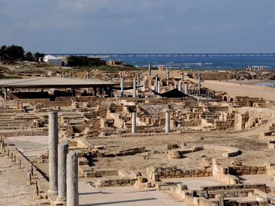
Caesarea Maritima was built from nothing by Herod the Great between about 22 and 10 BC, on an open and harbourless stretch of coast, and named for his patron Augustus. It became the Roman administrative capital of Judaea and the city the prefects actually lived in — Jerusalem was where they went when they had to.
The site at Caesarea Maritima holds a theatre still used for concerts, a hippodrome along the shore, the foundations of Herod’s promontory palace with a pool cut into the rock, a high aqueduct running up the beach, and Crusader walls and gatehouse laid over the top of the Roman city.
Herod had no bay, so he built one. Sebastos was an artificial harbour of hydraulic concrete poured into wooden forms underwater, using volcanic ash shipped from Italy — among the largest artificial harbours of the ancient world. And in 1961, reused as a step in the theatre at Caesarea, excavators turned up a limestone block inscribed with the name Pontius Pilate: the only contemporary record of him that exists anywhere.
3 – Baha’i Faith Gardens
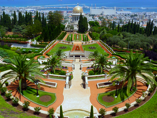
The Baha’i Gardens climb the north slope of Mount Carmel in Haifa in nineteen terraces, with the gold-domed Shrine of the Báb at the centre. The world centre of the Baha’i faith is here for a reason that has nothing to do with preference: the Ottomans exiled the religion’s founder, Baha’u’llah, to the prison city of Acre across the bay in 1868.
The terraces of the Baha’i Gardens run about a kilometre from the German Colony at the foot of the hill to the ridge above, laid out in rings around the shrine in clipped hedge, gravel and fountain. Free guided tours go down through them, the upper terrace has the view over Haifa bay, and UNESCO listed the Baha’i holy places in 2008.
The Báb, the faith’s herald, was executed by firing squad in Tabriz in 1850. His remains were hidden and moved from place to place for nearly sixty years before being buried on Mount Carmel in 1909. The gardens are kept by volunteers who come from around the world for fixed terms; the faith does not seek converts in Israel.
4 – Masada

Masada is a flat-topped rock standing some 400 metres above the western shore of the Dead Sea, fortified as a palace and refuge by Herod in the 30s BC and later held by Jewish rebels during the revolt against Rome. The Romans besieged Masada and took it in 73 or 74 AD. You go up by cable car or on foot up the Snake Path, which takes about an hour.
On top are Herod’s northern palace on three terraces cut into the cliff, storerooms, a bathhouse and enormous rock-cut cisterns; below, the Roman siege camps and the assault ramp are still plainly visible in the desert, among the best-preserved siege works anywhere in the Roman world. The famous part — that 960 defenders killed themselves rather than be taken — comes from Josephus, who was not there, and from no other ancient source.
Excavation at Masada found the remains of about twenty-eight people. Some scholars accept the account and others read it as a literary set piece; archaeology cannot settle it. The Israeli army once held induction ceremonies on the summit and no longer does.
5 – Sea of Galilee
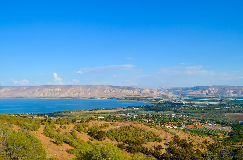
The Sea of Galilee is not a sea but a freshwater lake about twenty-one kilometres long, fed and drained by the Jordan, and at roughly 210 metres below sea level it is the lowest freshwater lake on earth. It is also Israel’s largest natural freshwater reserve and the source of the national water carrier.
The northern shore of the Sea of Galilee carries the Christian sites: Capernaum, where the foundations of a first-century house long venerated as Peter’s lie beneath a modern church; Tabgha; the Mount of Beatitudes. Tiberias on the western shore is the town, with hot springs, beaches and boats across.
In 1986 a drought dropped the water far enough to expose something in the mud on the northwest shore — a wooden fishing boat eight metres long, built in the first century AD and preserved by the silt that buried it. Two brothers from a kibbutz on the shore found it. It is now in a museum at Ginosar, and it is the only boat of its kind and date ever recovered here.
6 – Dead Sea
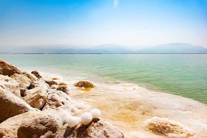
The Dead Sea lies about 430 metres below sea level, the lowest exposed land on the planet, in the rift valley along the border between Israel and Jordan. At roughly ten times the salinity of the ocean nothing lives in it, which is where the name comes from, and the density is what makes floating effortless rather than a skill.
The western shore of the Dead Sea has the beaches and the mud, the spa hotels around Ein Bokek, and the oasis, waterfalls and pools of Ein Gedi a short way north. The air at this depth is measurably richer in oxygen and filters more ultraviolet than anywhere else, which is why dermatology clinics have operated on the shore for decades. The Dead Sea is disappearing.
The Jordan is drawn off upstream by every country that shares it and the mineral works evaporate more, and the surface has been dropping by around a metre a year for decades. As the water retreats it exposes buried salt that dissolves underground, and thousands of sinkholes have opened along the shore, taking roads, palm groves and beaches with them.
7 – Negev Desert
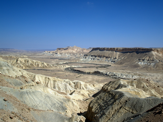
The Negev covers more than half of Israel’s land area: a triangle of rock desert, canyon and dust running south from Beersheba to Eilat, crossed for centuries by the Nabataean incense route that carried frankincense and myrrh from Arabia to the Mediterranean ports.
The Negev holds the ruined Nabataean towns of Avdat, Shivta and Mamshit, UNESCO-listed in 2005; the spring-fed pools of Ein Avdat canyon; Ben-Gurion’s grave at Sde Boker, where he went to live after leaving office to make the point that the desert could be settled; and the Ramon crater, with a small town on its rim. That crater is not a crater.
Makhtesh Ramon is forty kilometres long and five hundred metres deep, and it was made by erosion rather than impact — water cut through a hard upper layer and hollowed out the softer rock beneath it. There are only a handful of makhteshim anywhere, five of them in the Negev and the rest in Sinai, and geologists use the Hebrew word because no other language had need of one.
8 – Tel Aviv
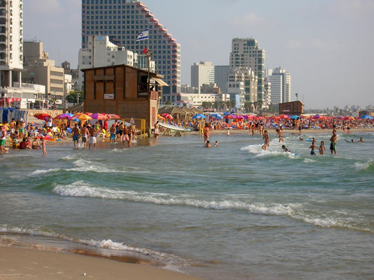
Tel Aviv was founded in 1909 by sixty-six families who bought sand dunes north of Jaffa and drew lots for the plots using seashells. Within thirty years it was the largest city in the country, and Tel Aviv-Yafo is now Israel’s commercial and cultural centre, with fourteen kilometres of Mediterranean beach along its western edge.
Tel Aviv has Rothschild Boulevard and Independence Hall, where the state was declared in 1948; the Carmel market; the low nineteenth-century lanes of Neve Tzedek; the Tel Aviv Museum of Art; the converted port; and a beach promenade running the whole way south to Jaffa.
The centre of Tel Aviv holds more than four thousand International Style buildings — flat roofs, long balconies, curved corners, white render — the largest concentration anywhere in the world. Most went up in the 1930s, designed by German-Jewish architects trained at the Bauhaus who left Germany after 1933 and found a city of empty dunes to build on. UNESCO listed it as the White City in 2003.
9 – Jaffa

Jaffa is one of the oldest working ports on earth, in use since the Bronze Age and named in Egyptian records, the Hebrew Bible and Greek myth — cedar for Solomon’s Temple was landed here, Jonah sailed from here, and Andromeda was supposedly chained to the rocks offshore.
Its population, then overwhelmingly Arab, fell from around seventy thousand to a few thousand during the 1948 war, and Jaffa was merged into the municipality of Tel Aviv in 1950. The old town of Jaffa is a restored warren of stone lanes above the harbour, with a flea market, galleries and restaurants, an Ottoman clock tower at the entrance, St Peter’s Church, and a view back up the beach to the towers of Tel Aviv.
The Jaffa orange takes its name from this port. It is the Shamouti, a variety that appeared in local groves in the mid-nineteenth century — seedless, thick-skinned and tough enough to survive a sea voyage — and Arab and later Jewish growers shipped it out through Jaffa in such quantity that the name of the town became a brand across Europe.
10 – Acre
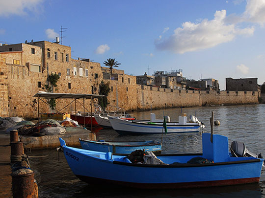
Acre — Akko in Hebrew, Akka in Arabic — is a walled port at the northern end of Haifa Bay, lived in since the Bronze Age, and after Saladin took Jerusalem in 1187 it became the capital of the Crusader Kingdom for a hundred years. When the Mamluks took Acre in 1291 it ended the Crusader presence in the Holy Land altogether.
The old city of Acre is Ottoman above and Crusader below: the green-domed al-Jazzar Mosque of 1781, caravanserais, a Turkish bath, a covered souk, a working fishing harbour, and sea walls that held off Napoleon in 1799. Underneath are the Knights’ Halls of the Hospitaller fortress and a 350-metre Templar tunnel running from the fortress down to the port.
The Crusader city at Acre survives because it was buried. When the Ottomans rebuilt the town in the eighteenth century they packed the medieval buildings with rubble and built on top of them, and the street you walk today is roughly eight metres above the twelfth-century one. The Templar tunnel was only found in 1994, by a resident trying to unblock a drain.
11 – Nazareth
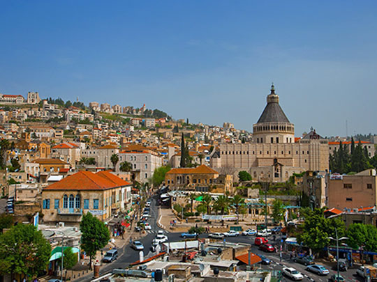
Nazareth is the largest Arab city in Israel, around eighty thousand people in the hills of Lower Galilee, with a Muslim majority and a substantial Christian minority. In the first century it was a village of a few hundred people, which is more or less the point: the Gospels present Jesus as coming from a place of no consequence whatever.
The Basilica of the Annunciation in Nazareth, finished in 1969, was the largest church in the Middle East when it was built. Its lower level centres on a grotto venerated as Mary’s house, with Byzantine and Crusader remains around it; the upper level is hung with mosaics of the Virgin donated by Catholic communities worldwide, each done in its own national manner.
The old souk runs downhill from the door. Nazareth has two Annunciations. Luke does not say where the angel appeared, and an apocryphal gospel places it at the village spring while Mary was drawing water — so the Greek Orthodox built their Church of St Gabriel over the spring, while Catholic tradition puts it at the house. Two churches, a few hundred metres apart, for the same moment.
12 – Eilat and the Red Sea
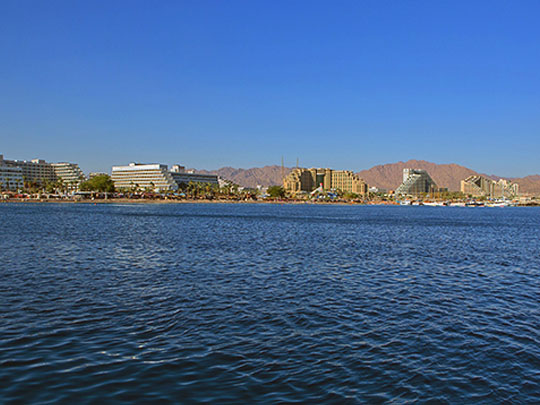
Eilat sits at the very southern tip of Israel on the Gulf of Aqaba, with about twelve kilometres of coastline and the borders of Egypt and Jordan both visible from the beach. It is the country’s only Red Sea port and its warm-water resort town, and the coral reef starts a few metres offshore.
The Coral Beach Nature Reserve at Eilat has a marked snorkelling trail over a fringing reef, there is an underwater observatory built out into the gulf, and dive sites run the length of the short coast. Eilat is also one of the great bird bottlenecks on earth — enormous numbers of migrants funnel through this gap between two deserts twice a year, and there is a ringing station on the salt pans. The corals at Eilat may be among the last left anywhere.
After the last ice age they recolonised the Red Sea from the Indian Ocean, and the hot shallow strait at its southern end filtered out everything that could not take the heat — so the survivors that reached the cool northern end arrived pre-adapted to temperatures far above what they meet here. Eilat’s reefs came through the world’s most extreme recorded marine heatwave, in 2024, without mass bleaching.