
Wikimedia Commons / CC-BY-SA-3.0 / GFDL
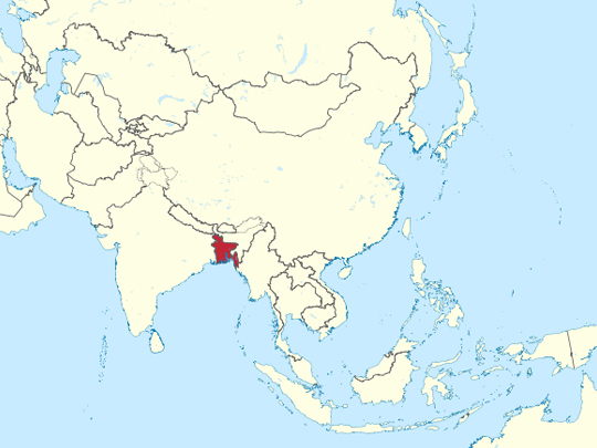
Capital: Dhaka
Population: 170 million+
Language: Bengali
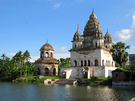
1 – Puthia Temple Complex (also above)
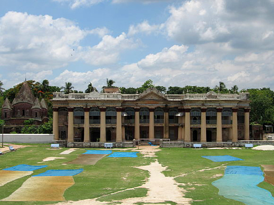
Twenty-odd kilometres east of Rajshahi, laid out around a lake and a long lawn, sits the largest concentration of historic Hindu temples anywhere in Bangladesh — around a dozen of them plus a palace, Puthia Temple Complex was built over roughly three centuries by the Puthia Raj family, who at their height held one of the wealthiest zamindari estates in British Bengal.
The Bhubaneshwar Shiva Temple at the entrance is the biggest Shiva temple in the country, a five-spired block raised in the 1820s by Rani Bhubanmoyi Devi with a black basalt lingam inside; behind the two-storey Rajbari stand the Govinda temples, their brick faces sheeted in terracotta panels of Krishna and Radha, battle, work and ordinary life.
A striking number of these temples were commissioned by widowed queens rather than by the rajas themselves — and then in 1950 East Pakistan abolished the zamindari system, the family left for India, and the estate has been quietly falling down ever since.
2 – Somapura Mahavihara – Paharpur
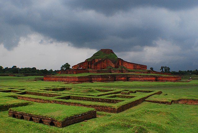
Somapura Mahavihara is an eleven-hectare walled quadrangle at Paharpur in Naogaon district, built at the end of the eighth century by Dharmapala of the Pala dynasty and identified from a clay seal turned up in the ruins — one of the five great monasteries of eastern India, and by area the largest of them.
Some 177 monks’ cells line the inside of the outer walls, each side running about 270 metres, enclosing a courtyard from which the cruciform central temple still rises around twenty metres; terracotta plaques of animals, dancers and deities run in bands round the base, and a site museum holds the finds.
UNESCO credits the terraced, cross-shaped design introduced here with influencing Buddhist temple building as far away as Bagan in Myanmar, the Javanese temples at Prambanan, and Cambodia — which makes a ruin in a Bangladeshi village arguably the prototype for half the great monuments of Southeast Asia.
3 – Alutila Cave
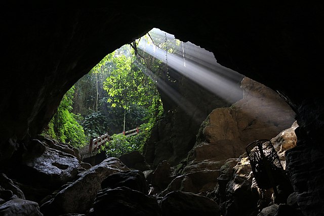
Alutila Cave is a hundred-metre natural tunnel running through Alutila — “potato hill” — about eight kilometres from Khagrachhari town in the northern Chittagong Hill Tracts; the Tripura people call it Matai Hakor, the cave where the god lives, which is the older name and the better one.
You buy a burning torch at the entrance because there is no lighting of any kind, then go down a long flight of steps into the hillside and wade through cold water running along the floor in the dark before coming out the far end; above ground there’s a viewpoint over the hills and a waterfall a short walk away.
Bangladesh is overwhelmingly flat and overwhelmingly Bengali, and the Hill Tracts are the exception on both counts — eleven indigenous peoples with their own languages and, for the most part, their own religions — which is the real reason to come up here, rather than the cave.
4 – Kaptai Lake
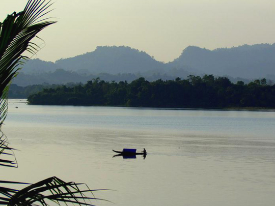
Six hundred and fifty square kilometres of water filling the valleys around Rangamati, and none of it is natural: between 1957 and 1962 the Pakistani government dammed the Karnaphuli at Kaptai, with American money and American contractors, to build Kaptai Lake, what is still the only hydroelectric station in Bangladesh.
Boats run out from Rangamati across water studded with drowned hilltops that are now islands, to the hanging bridge, the Chakma Raja’s palace and the Buddhist temple at Rajbon Bihar; in a very low year the water drops far enough that the roof of the old royal palace breaks the surface.
The reservoir drowned about 40 per cent of the region’s arable land and displaced roughly a hundred thousand people, most of them Chakma, on compensation terms still disputed today — and the grievance it left behind fed an insurgency in the Hill Tracts that ran until a peace accord in 1997.
5 – Jaflong
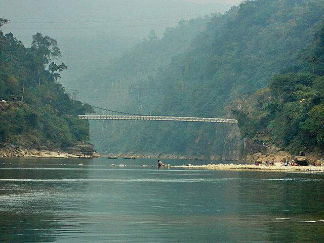
Jaflong, where the Piyain comes down out of the Khasi hills and crosses from Meghalaya into Bangladesh, about sixty kilometres from Sylhet, the river arrives carrying boulders — and for decades the local economy has been people standing waist-deep in it lifting stones out by hand and by boat.
The draw is the view upstream to the Indian hills and the Dawki suspension bridge, with tea gardens, betel and areca groves and Khasi villages on the slopes behind; the riverbed itself is what people photograph, clear green water running over pale rock.
The stone is also the problem — extraction has been heavy enough that an entire Khasi settlement was washed into the riverbed in the 1980s, and the government eventually declared a fifteen-square-kilometre stretch an Ecologically Critical Area and banned mechanical quarrying — but enforcement comes and goes with successive governments, and every lapse takes more of the river with it.
6 – Kantajew Temple
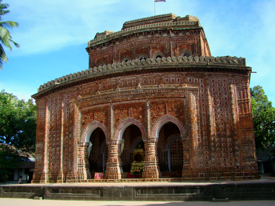
Twenty kilometres north of Dinajpur, on an island in the Dhepa river, stands Kantajew Temple, the finest terracotta building in Bangladesh — begun around 1704 by Maharaja Pran Nath, zamindar of Dinajpur, and completed by his adopted son Ram Nath in 1752, dedicated to Krishna and his consort Rukmini.
Every outward surface is tiled with small moulded terracotta plaques, thousands of them, running in bands around three storeys of receding terraces and cusped arches; the Ramayana and the Mahabharata are up there, but so are hunting parties, river boats, musicians, hookahs and Europeans in their hats.
It was built in the navaratna style with nine spires, and all nine came down in the great Assam earthquake of 1897 and were never rebuilt — so the most photographed building in northern Bangladesh has stood for well over a century exactly as the earthquake left it.
7 – Boga Lake
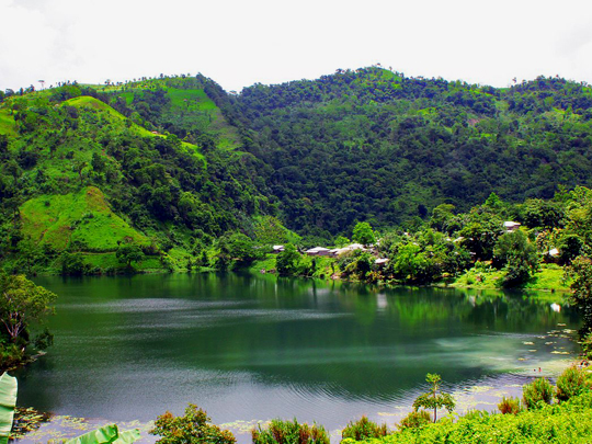
Boga Lake, a deep, roughly circular lake at about 380 metres in the Bandarban hills, reached by a rough track up from Ruma and long used as the staging post for the walk to Keokradong — it has no obvious inlet or outlet, and its crater shape has had geologists arguing about volcanism and landslides for half a century.
A Bawm village sits on the rim and staying there in a bamboo cottage is most of the point; the water shifts colour through the day with the light, and a survey in 1973 found it too acidic to support life, though by the 1990s it had filled with fish.
The Bawm word for the lake is their word for a dragon, and the story is that one lived in these hills and ate the village’s livestock and then its children, until the villagers finally killed it — at which point the mountain top fell in, water rose through the hole, and the settlement went under.
8 – St. Martin’s Island
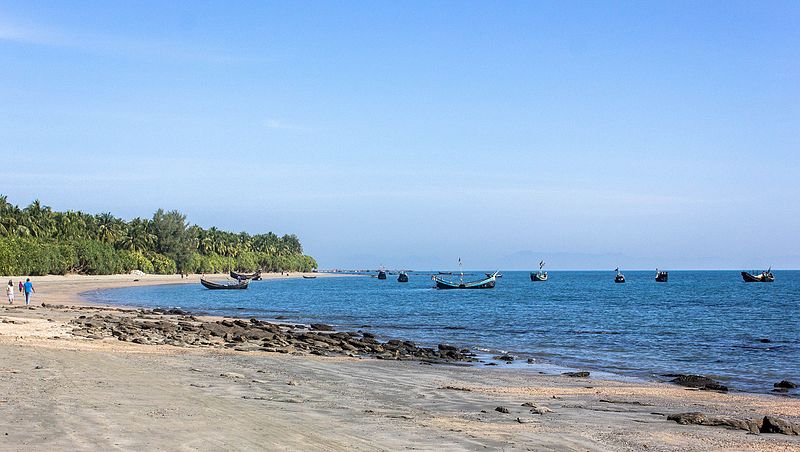
Eight square kilometres of sand and rock in the Bay of Bengal, a hundred and twenty kilometres from Cox’s Bazar and only a few kilometres off Myanmar, known locally as Narikel Jinjira — Coconut Island — and nationally as Bangladesh’s coral island, though marine scientists point out it is really a sedimentary island that happens to carry the country’s only coral.
You can walk the whole of St. Martin’s Island in a day, past coconut palms, rock pools and seaweed farms, with Chhera Dwip, the detached southern tip, reachable when the tide is out; there are something like forty-six coral species in the water and turtles nesting on the beaches.
Unrestricted tourism did enough damage that in 2024 the government closed the island for nine months of the year, capped daily visitor numbers and cut overnight stays back to two months — which flattened the local tourist economy, and is the trade-off every fragile island ends up facing sooner or later.
9 – Sonargaon
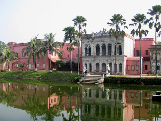
Thirty kilometres southeast of Dhaka, Sonargaon was on and off the seat of government in Bengal from the thirteenth century, a capital under the sultans and later the base of Isa Khan, who led the Baro-Bhuiyan chieftains in holding out against Mughal expansion — and it was the centre of the trade in Dhaka muslin.
What survives best is Panam Nagar, a single street of around fifty abandoned merchant houses built by Hindu cloth traders in the late nineteenth and early twentieth centuries, stuccoed and shuttered and now roped off as they come down; the Sardar Bari nearby holds the folk art museum.
Dhaka muslin was spun from phuti karpas, a cotton that grew only on these riverbanks, at thread counts nobody has matched since; the plant went extinct and the craft died out after the 1850s, and a Bangladeshi research project spent years DNA-matching surviving wild cottons against a muslin sari in a London museum to work out what had been lost.
10 – Lalbagh Fort – Dhaka
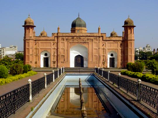
Lalbagh Fort, an unfinished Mughal fort on what was once the bank of the Buriganga in Old Dhaka, begun in 1678 by Prince Muhammad Azam Shah, third son of the emperor Aurangzeb, during a viceroyalty in Bengal that lasted fifteen months before his father recalled him to Delhi.
Three buildings were completed and still stand — the Diwan-i-Aam with its hammam, the three-domed Quilla Mosque, and between them the white marble tomb of Pari Bibi — set in lawns and water channels, with the densest part of the old city pressing up against the walls outside.
The reason it was never finished is that Pari Bibi died there in 1684: she was the daughter of Shaista Khan, the governor who had taken over the works, and betrothed to Azam, and after her death Shaista Khan decided the place was inauspicious and simply stopped — leaving the fort half-built for three and a half centuries.
11 – The Sundarbans
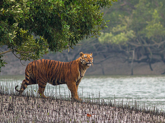
The Sundarbans is largest mangrove forest on earth spreads across the mouths of the Ganges, Brahmaputra and Meghna, roughly 10,000 square kilometres in all with about 6,000 of them on the Bangladeshi side — a maze of tidal creeks, mudflats and salt-tolerant islands that doubles as the country’s storm barrier, taking the force of cyclones that would otherwise hit the delta unbroken.
Boats go in from Mongla and Khulna for two or three days at a time, down channels narrow enough to touch both banks, past spotted deer, estuarine crocodiles, macaques and some 260 bird species, with Ganges river dolphins surfacing in the wider reaches and the tigers almost never showing themselves.
They are there, though, and they swim between islands and are the only tiger population anywhere that regularly hunts people — which is why the honey collectors who go in each spring, Hindu and Muslim together, pray first to Bonbibi, the Lady of the Forest, a goddess who belongs to neither religion and is claimed by both.
12 – Bagerhat
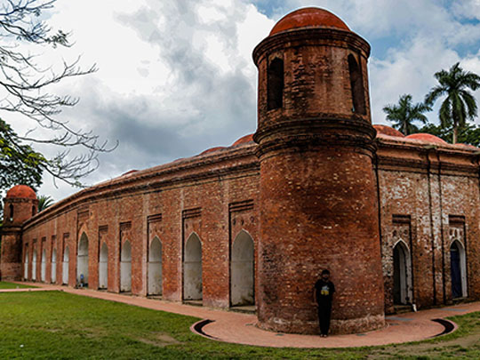
In the 1440s a Sufi saint and soldier called Khan Jahan Ali arrived on the northern fringe of the Sundarbans, cleared the mangrove, dug reservoirs and laid out a planned city he named Khalifatabad — around fifty domed brick mosques, tombs, roads and bridges survive across the site, which is why UNESCO listed the whole thing in 1985 as the Mosque City of Bagerhat.
The Shat Gombuj Masjid is the centrepiece and the largest surviving mosque of the Bengal Sultanate, a long hall of slender stone pillars under a low ceiling of domes with four tapering corner towers outside, built in brick and laterite rather than stone; Khan Jahan’s own tomb, the Nine Dome Mosque and the enormous Ghora Dighi tank are all within a few kilometres.
The name is a puzzle: the Sixty Dome Mosque has seventy-seven domes over the prayer hall, four more on the corner towers, and exactly sixty stone pillars holding them up — so the likeliest explanation is that it was always the sixty-pillar mosque, and somewhere along the way the Bengali word for pillar got swapped for the word for dome.