
Wikimedia Commons / CC-BY-SA-3.0 / GFDL
Capital: Managua
Population: 7 million+
Language: Spanish / Miskito / Creole English / Mayangna / Nicaraguan Sign Language
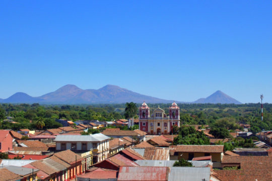
1 – Leon (above)
Nicaragua’s second city and its intellectual centre — the university here dates from 1812 and the place has been the liberal counterweight to conservative Granada for two centuries; it isn’t even on its original site, having shifted about 30 km west in 1610 after Momotombo erupted, leaving the first town behind as the ruins now protected as León Viejo.
The Basílica de la Asunción is the largest cathedral in Central America, built between 1747 and 1814 with walls thick enough to have survived earthquakes, volcanic ash and shelling in two separate civil wars, and you can climb out onto its white roof; Rubén Darío, the poet who remade Spanish-language verse, is buried in the crypt below.
The modern reason backpackers turn up is Cerro Negro, an hour out of town: the youngest volcano in Central America, a cone of loose black grit that people now sled down on plywood boards at genuinely alarming speed, an activity a local hostel is credited with inventing in 2004.
2 – Fortaleza – Río San Juan
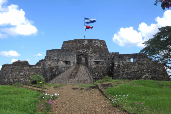
The Fortaleza de la Limpia Pura e Inmaculada Concepción stands above the rapids of the Río San Juan in the far south-east, built between 1673 and 1675 after pirates coming up the river sacked Granada three times in five years — and in 1762 it was held against a British fleet by Rafaela Herrera, the 19-year-old daughter of the commander, who took over the defence when her father died and is a national heroine to this day.
The village of El Castillo below it has no cars at all, just a line of houses along the water with the fort on the hill above, and boats run downriver from here into the Indio Maíz rainforest reserve or back up towards Lake Nicaragua.
The British returned in 1780 and this time took the place — one of the officers was a 21-year-old captain named Horatio Nelson — but the expedition was a catastrophe, with roughly 2,500 of its 3,000 men dead, almost all of disease, and Nelson shipped home so ill he very nearly died.
3 – Managua

Managua was a lakeside town of no particular importance until 1852, when it was made capital purely because it sat halfway between León and Granada and neither would accept the other; it has since been knocked flat twice by earthquakes, in 1931 and again on 23 December 1972, when the centre came down and thousands were killed.
The shell of the old cathedral still stands on the Plaza de la Revolución, empty and unsafe, with the National Palace of Culture beside it; up the hill is the Loma de Tiscapa crater and its Sandino silhouette, and out by the lake are the Huellas de Acahualinca, human footprints pressed into volcanic mud thousands of years ago.
The city never got its street grid back, so nobody really uses addresses: directions come as landmarks, counted in blocks and old Spanish varas, with “toward the lake” standing in for north — and the landmarks include things that stopped existing decades ago, so you’ll be sent two blocks from where a particular tree, or a Pepsi bottling plant, used to be.
4 – San Juan Del Sur
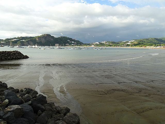
A horseshoe bay on the Pacific about 20 km from the Costa Rican border, and in the 1850s the western end of the fastest route from New York to San Francisco: Cornelius Vanderbilt’s steamers came up the Río San Juan and across Lake Nicaragua, and a twelve-mile stagecoach ride finished the crossing here, where another ship was waiting for California.
It is now the country’s main surf town — the bay itself is calm and forgiving for beginners, with the heavier breaks at Maderas and Playa Hermosa a short drive north and south — and a huge Christ statue stands on the northern headland looking down over the whole thing.
Among the roughly 75,000 people who crossed Nicaragua on Vanderbilt’s route was Mark Twain, who came through in the winter of 1866 heading east and filed a run of dispatches to a San Francisco paper, complaining cheerfully about the sandwiches served on the lake boat.
5 – Bosawas Reserve
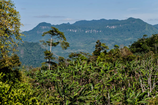
Up against the Honduran border in the far north, Bosawás is the largest protected area in Central America — something like 20,000 sq km of rainforest, cloud forest and river, which works out at roughly 15% of Nicaragua’s entire land area — and became a UNESCO biosphere reserve in 1997.
Around 40,000 people live in and around it, mostly Mayangna and Miskito holding legal title to six indigenous territories; there are effectively no roads, so travel means rivers and a guide, with Cerro Saslaya and the Peñas Blancas massif the usual objectives — though settler cattle ranching and gold mining have taken a hard bite out of the forest, and the communities defending it have faced real violence.
The name isn’t a word at all: it’s an acronym assembled from the three landmarks that bound the place — the Río Bocay, Cerro Saslaya and the Río Waspuk.
6 – Canon De Somoto

In the dry northern hills near the Honduran border, two rivers meet — the Tapacalí out of Nicaragua and the Comalí out of Honduras — and immediately start cutting into volcanic rock laid down some thirteen million years ago, forming both this canyon and the Río Coco, the longest river in Central America.
It runs about three kilometres, with walls up to 190 m that squeeze down to four or five metres across at the narrowest points, so the standard trip is half hike and half swim — floating the narrows, jumping off ledges — run by local guiding co-operatives out of Somoto town.
People living nearby had always known it was there, but it went scientifically undocumented until 2004, when geologists from the Czech Geological Survey came upon it while mapping the area — and three years after that it was on the fifty-córdoba banknote.
7 – Granada
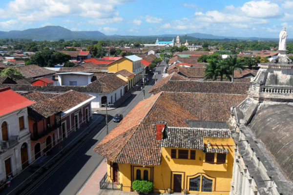
On the shore of Lake Nicaragua beneath the Mombacho volcano, Granada was founded in 1524 and has a solid claim to being the oldest Spanish-founded city on the American mainland still standing where it was originally put; it’s known as La Gran Sultana, for the Moorish-Andalusian look it took from its namesake in Spain.
The yellow cathedral on the plaza, the Convento San Francisco with its collection of pre-Columbian statues, and the bell tower of La Merced for the view across the roofs; out on the water, Las Isletas is an archipelago of some 365 small islands flung off Mombacho in an eruption, best seen from a boat.
In December 1856 the American filibuster William Walker, by then installed as president of Nicaragua and losing his war, ordered the city burned; his men took a fortnight over it and left a sign in the ruins reading Aquí fue Granada — “Here was Granada”.
8 – Little Corn Island
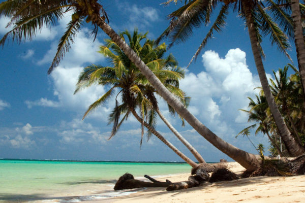
A speck of about three square kilometres in the Caribbean some 70 km off Bluefields, reached by plane to Big Corn and then a small boat across; this was Mosquito Coast rather than Spanish Nicaragua for most of its history, which is why the islanders are Creole and speak English at home.
There are no cars and no roads, only footpaths, and life runs on lobster fishing, diving and a scattering of guesthouses; every August the islands mark the day in 1841 when a British official stood up at South West Bay and declared the end of slavery, with a festival built around crab soup.
Under the Bryan–Chamorro Treaty of 1914 Nicaragua leased both Corn Islands to the United States for ninety-nine years, subject to American law rather than Nicaraguan; the lease ran until 1971, and in all that time the only thing the Americans ever actually built here was a lighthouse.
9 – Ometepe
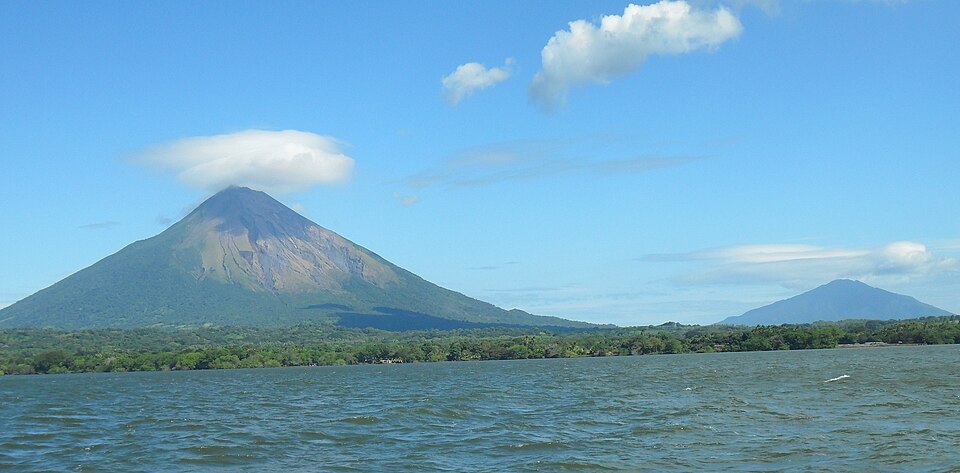
Two volcanoes rising straight out of Lake Nicaragua and joined by a low isthmus, so that from the air the island reads as a rough figure of eight — Concepción still active at 1,610 m, Maderas dormant with a lake in its crater at 1,394 m; the name is Nahua, ome tepetl, “two mountains”, and people have been living here since roughly 2000 BC.
The ferry from San Jorge takes about an hour to Moyogalpa and a rented motorbike handles the dirt roads after that; the island holds thousands of petroglyphs cut into boulders, black basalt statues standing beside the church at Altagracia, the San Ramón waterfall, the spring-fed pools at Ojo de Agua, and two long, punishing volcano climbs.
The lake around it has bull sharks in it, assumed for a century to be a landlocked species stranded when the lake formed — until tagging work in the 1960s and 70s showed them moving freely in both directions between here and the Caribbean, hauling themselves up the rapids of the Río San Juan like salmon.