
Allan Grey / Wikimedia Commons / CC-BY-SA-3.0 / GFDL
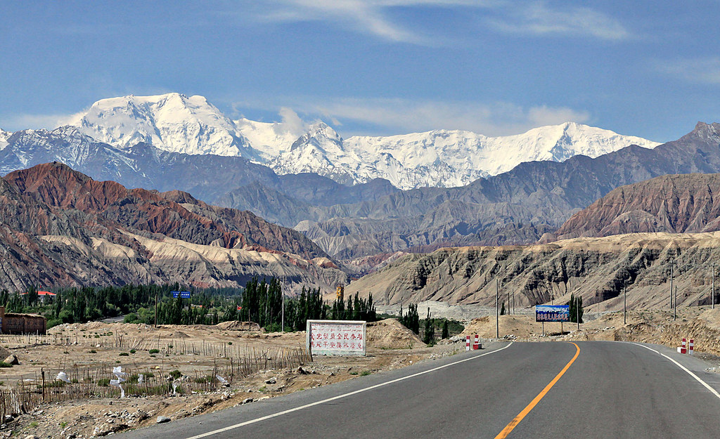
Capital: Islamabad
Population: 255 million+
Language: Punjabi/English/Urdu
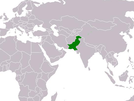
1 – Karakoram Highway (also above)
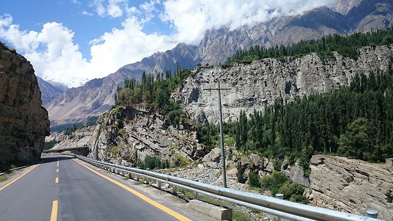
The Karakoram Highway runs 1,300 kilometres from Hasan Abdal in the Punjab to Kashgar in Xinjiang, crossing into China at the Khunjerab Pass — at 4,693 metres, the highest paved international border crossing anywhere in the world. Pakistan and China began it in 1959 and finished in 1979; it opened to the public in 1986.
The Karakoram Highway follows a branch of the old Silk Road up the Indus and then the Hunza river, through the point where the Himalaya, the Karakoram and the Hindu Kush meet. There are five tunnels and a great many bridges, and sections are regularly closed by landslide — a 2010 slip dammed the Hunza river and drowned nineteen kilometres of the road.
Twenty years of construction cost around 810 Pakistani and 200 Chinese lives, most of them to landslides and falls — roughly one death for every kilometre and a half of road. More than 140 of the Chinese workers are buried in a cemetery at Gilgit, which is tended, and which most people driving the highway pass without noticing.
2 – Hunza Valley
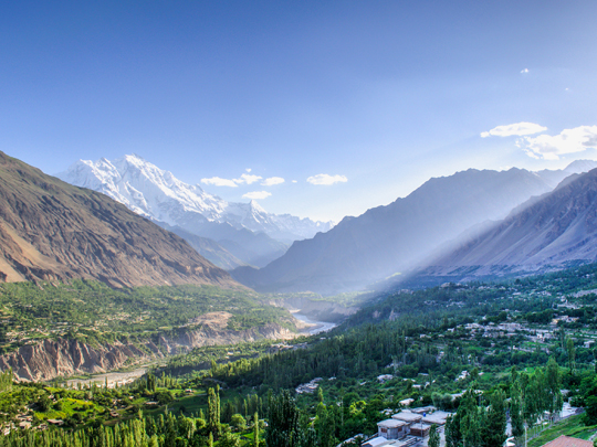
Hunza is a valley in Gilgit-Baltistan at around 2,500 metres, walled in by seven-thousand-metre peaks — Rakaposhi and Ultar Sar stand over it — and it was an independent princely state until 1974. Apricots, cherries and walnuts grow on terraces above the river, and the whole valley turns colour in late October.
Two forts look down on Hunza from the villages of Karimabad and Altit: Baltit, around seven hundred years old, and Altit, older still, both restored by the Aga Khan Trust for Culture and open to visit. Hunza has also long been credited with extraordinary longevity — a claim rooted in no birth records and unsupported by anyone who has looked.
The language spoken in Hunza is Burushaski, and it is related to nothing. Around a hundred thousand people speak it, and despite a century of attempts nobody has convincingly connected it to any other language family on earth — not Indo-European, not Sino-Tibetan, not Dravidian. It is a genuine isolate, sitting in a valley on a road between two of the world’s great language zones.
3 – Deosai National Park

Deosai is a plateau in Gilgit-Baltistan averaging around 4,100 metres, which makes it one of the highest plateaus in the world, and it covers some three thousand square kilometres between the Karakoram and the western Himalaya. Snow closes it from about November to May; for the few months it is open it fills with wildflowers. The local name for Deosai means the land of giants.
There are no trees on it at all — it is above the treeline entirely — and the scale is hard to read because there is nothing to judge it against. Sheosar Lake sits at 4,142 metres near the western edge, and the road across runs between Skardu and Astore. Deosai exists as a park because of a bear.
The Himalayan brown bear here had fallen to fewer than twenty animals by the early 1990s, hunted for skins and body parts, and the plateau was protected in 1993 specifically to save them. The population has since climbed past seventy. It is one of the more successful things conservation has done in Pakistan.
4 – Lahore Fort
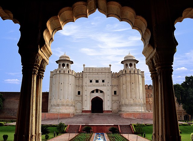
Lahore Fort stands at the northwest corner of the Walled City, on ground that has been fortified for a thousand years, though the fort as it exists was rebuilt in brick by Akbar from 1566 and added to by every Mughal emperor after him. UNESCO listed it in 1981 along with the Shalimar Gardens across the city.
Inside Lahore Fort are Shah Jahan’s Sheesh Mahal of 1631, its ceilings set with tens of thousands of mirror fragments; the Naulakha pavilion; and Aurangzeq’s Alamgiri Gate, built wide enough to take elephants. Along the western side runs the Picture Wall — some 450 metres of glazed tile mosaic showing elephants, camels, hunters and angels, the largest thing of its kind anywhere.
In March 1849 the Sheesh Mahal was where the Sikh empire ended. The Last Treaty of Lahore was signed in that room, and under it the ten-year-old Maharaja Duleep Singh surrendered the Punjab to the East India Company and handed over the Koh-i-Noor. The stone had reached Lahore from Delhi by way of Persia and Afghanistan; from here it went to London.
5 – Lake Saiful Malook
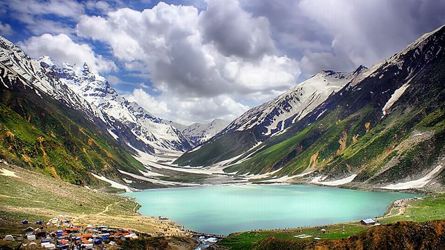
Lake Saiful Malook sits at around 3,220 metres at the head of the Kaghan valley in Khyber Pakhtunkhwa, in a bowl below Malika Parbat, which at 5,290 metres is the highest peak in the range. It is fed by glacier melt, it freezes over in winter, and the road up to it is open only in the warm months.
The water at Lake Saiful Malook is clear enough to show the bottom near the shore and takes the reflection of the peaks when there is no wind. Boats go out across it, the jeep track up from Naran is rough and busy in season, and the meadows above lead on towards the Ansoo lake.
The lake is named after a story. Saif-ul-Malook is a Punjabi epic written by Mian Muhammad Bakhsh in 1863, in which a Persian prince falls in love with a fairy princess he has seen in a dream and comes to this lake to find her. The poem is still sung, and the lake is named for the prince rather than the other way round.
6 – Masjid Wazir Khan
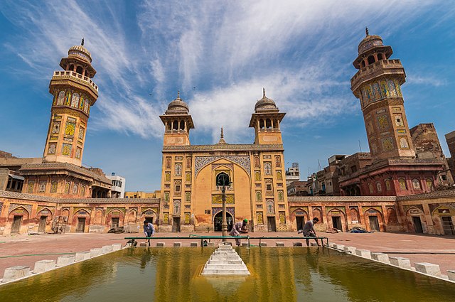
The Wazir Khan Mosque was built between 1634 and 1641 inside Lahore’s Walled City by Hakim Ilam-ud-din Ansari, a physician from Chiniot who rose to become Shah Jahan’s governor of Lahore and was known by the title Wazir Khan. It went up over the shrine of a fourteenth-century Sufi saint, which is still inside it.
You reach the Wazir Khan Mosque through the Delhi Gate and down a bazaar street, and the building appears all at once — a brick courtyard mosque with four octagonal minarets and a forecourt of shops, the rents from which were meant to maintain it. The Aga Khan Trust for Culture spent most of the last decade restoring it. What makes it remarkable is the tile.
The Wazir Khan Mosque is covered inside and out in kashi-kari — cut glazed tilework in floral and geometric patterns, with panels of calligraphy running through it — and it is the most extensively tiled building of the entire Mughal period. The technique is named for Kashan in Persia, where it came from.
7 – Mohenjo-daro
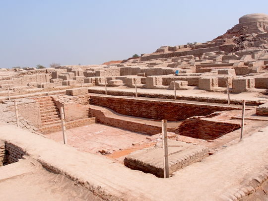
Mohenjo-daro stands on the Indus in Sindh and was one of the largest cities in the world around 2500 BC, with perhaps forty thousand people in it. It belonged to the Indus Valley civilisation, which ran across what is now Pakistan and northwest India and was contemporary with Egypt and Sumer. UNESCO listed it in 1980.
The city at Mohenjo-daro was planned: streets on a grid, standardised fired bricks, covered drains along the main roads, wells in most houses and bathing platforms in many. The Great Bath on the citadel mound is a watertight brick tank about twelve metres by seven — the earliest public water tank known anywhere. Nobody can read a word of it.
The Indus script survives on thousands of seals and tablets, around four hundred distinct signs, and it has resisted every attempt at decipherment for a century — there is no bilingual text, no Rosetta Stone, and no certainty about what language it even recorded. We know how these people plumbed their houses and nothing about what they thought.
8 – Mohatta Palace
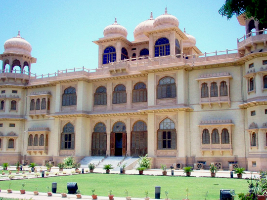
Mohatta Palace stands in Clifton, in Karachi, and was built in 1927 as a summer house for Shivratan Chandraratan Mohatta, a Hindu businessman from Marwar who had made his money in Karachi. The architect was Ahmed Hussain Agha, and the building is pink Jodhpur stone above yellow Gizri stone from the local quarries.
Mohatta Palace is Rajasthani in style — domes, balconies, carved stone screens — dropped into a Karachi seafront suburb, with nine domes and a good deal of Hindu temple detailing on a private house. It is a museum now, and the exhibitions change; the building is usually the better part of the visit.
The house tells the story of the city in three owners. Mohatta built it in 1927 and left for India at Partition in 1947, twenty years later. The government took it over and used it for the foreign ministry. Then from 1964 until her death it was the home of Fatima Jinnah — sister of Pakistan’s founder, and the opposition candidate who stood against Ayub Khan and lost.
9 – K2
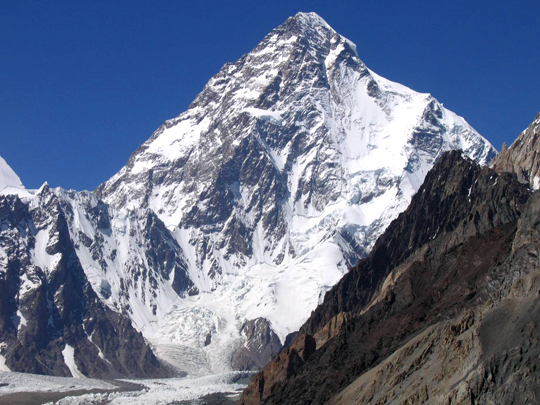
K2 rises to 8,611 metres on the border between Pakistan and China: the second-highest mountain on earth, and by general agreement the hardest of the fourteen peaks over eight thousand metres. It is approached and climbed from the Pakistani side. An American on the 1953 expedition called it a savage mountain that tries to kill you, and the name has stuck.
Getting to K2 takes about a week on foot from the roadhead at Askole, up the Baltoro glacier to Concordia, where several of the world’s highest mountains stand around a single junction of ice. Two Italians made the first ascent in 1954, and K2 was the last eight-thousander to be climbed in winter — a Nepali team did it in January 2021, stepping onto the summit together.
K2 is the only major mountain on earth still known by a survey code. In 1856 Thomas Montgomerie sketched the Karakoram from two hundred kilometres away and labelled the two clearest peaks K1 and K2, meaning nothing more than the order he drew them in. K1 turned out to be Masherbrum locally; K2 had no name anyone used, so the label stayed. Its being second-highest is a coincidence.
10 – Taxila
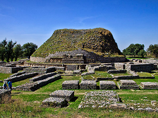

Taxila lies about thirty kilometres northwest of Islamabad, and it is not one site but a dozen spread across a valley and spanning a thousand years — three successive cities and a scatter of Buddhist monasteries. UNESCO listed the whole complex in 1980. Alexander came through in 326 BC and was received by the local king without a fight.
The oldest city at Taxila is Bhir Mound, Achaemenid and Mauryan; Sirkap, built by Indo-Greeks in the second century BC, is laid out on a grid with side streets at right angles to a main avenue; Sirsukh is Kushan. Around them stand the Dharmarajika stupa, which has an Ashokan core, and the monasteries at Jaulian and Mohra Muradu.
For the first few centuries after his death, the Buddha was not shown as a person at all. He was indicated by symbols — a footprint, an empty throne, a wheel, a parasol over nothing. It was in Gandhara, of which Taxila was a principal centre, that he was first carved as a man, in a style with Hellenistic drapery and Greek faces. Most Buddha images since descend from work made here.
11 – Badshahi Mosque
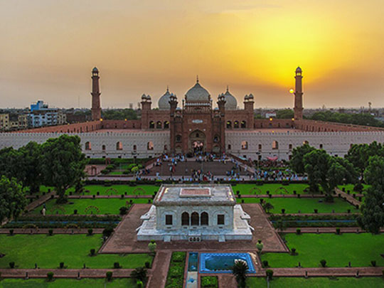

The Badshahi Mosque stands across a square from Lahore Fort and was built between 1671 and 1673 by Aurangzeb, the last of the great Mughal emperors, under the supervision of his foster brother Muzaffar Hussain. It was the largest mosque in the world when it was finished, and it remained the largest for more than three hundred years.
Red sandstone with marble inlay, three white marble domes and four minarets of around fifty-three metres, and a courtyard at the Badshahi Mosque that takes something like a hundred thousand people. A room above the gate holds relics attributed to the Prophet and his family. Ranjit Singh’s tomb and the poet Iqbal’s stand in the square outside.
Within a few decades of Aurangzeb’s death the empire that built it had collapsed, and the Badshahi Mosque spent much of the nineteenth century as a barracks. The Sikhs stabled horses in the courtyard and stored gunpowder in it; the British garrisoned it and cut gun emplacements into the walls. It was handed back in 1852, and the serious restoration was not finished until 1960.
12 – Makli Necropolis
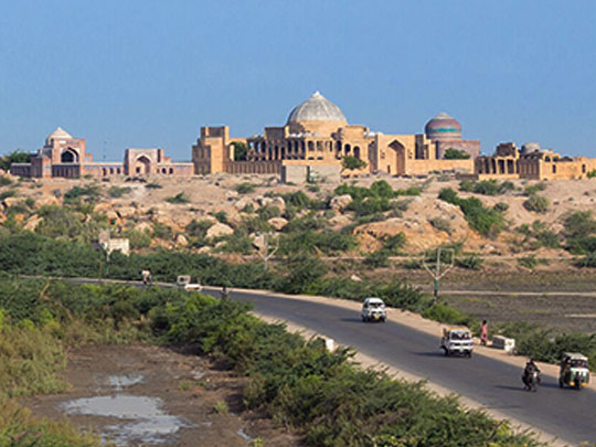

Makli is a burial ground on a ridge above Thatta in Sindh, and it covers something in the order of ten square kilometres. Estimates of how many tombs and graves stand on it begin at half a million. They date from the fourteenth century to the eighteenth, and UNESCO listed Makli in 1981.
The grand tombs at Makli belong to the rulers and saints of four successive dynasties — Samma, Arghun, Tarkhan and Mughal — and the style changes as you walk between them. Jam Nizamuddin’s tomb of around 1509 is carved yellow sandstone; Isa Khan Tarkhan’s of 1644 is a two-storey stone pavilion; Diwan Shurfa Khan’s is faced in blue tile.
The strange thing about the stonework at Makli is that much of it is not Islamic in manner at all. The Samma tombs were cut by craftsmen working in a Hindu and Gujarati temple idiom — lotus rosettes, chain-and-bell motifs, figures — because those were the masons available. Thatta below was once the capital of Sindh and a great trading port. It is a small town now, and the cemetery has outlasted it.