
Wikimedia Commons / CC-BY-SA-3.0 / GFDL
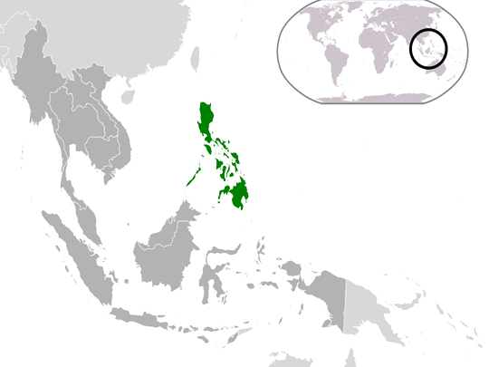
Capital: Manila
Population: 112.5 million+
Language: Filipino and English
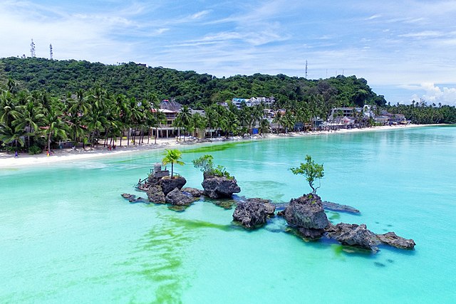
1 – Boracay (above)
Boracay is a ten-square-kilometre island off the northwestern tip of Panay, in the central Philippines, and for forty years it has been the country’s most famous beach — a four-kilometre run of fine white sand that took it from a place backpackers reached by outrigger in the 1970s, after a German guidebook writer called it paradise, to an island handling around two million visitors a year.
White Beach is the whole show at Boracay: powder sand, water shallow enough to wade a long way out, Willy’s Rock standing offshore with a small shrine built on top of it, and behind the sand a strip that was, until recently, solid bars — the island was closed completely for six months in 2018 after President Duterte called it a cesspool, and reopened with its drains rebuilt, hundreds of structures demolished and the beach cleared of parties, deckchairs and barbecues.
Among the rules Boracay came back with in October 2018: sandcastles now require official approval, which sounds like comedy until you learn the builders had been charging tourists to pose with them.
2 – Puerto Princesa Underground River
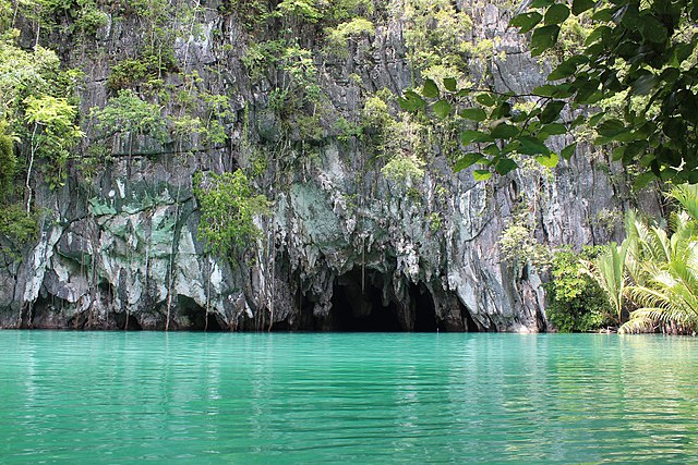
The Puerto Princesa Subterranean River runs 8.2 kilometres through a limestone mountain on the west coast of Palawan and empties straight into the South China Sea — one of very few navigable underground rivers anywhere that reaches open ocean under its own power; UNESCO listed it in 1999.
Boats go into the Puerto Princesa cave paddled and by lamplight — the navigable stretch runs about 4.3 kilometres, though the standard tour turns back well before that — through chambers of stalactites, beneath a dome some 300 metres across, under nine species of bat, and because the tide pushes in at the mouth the water under the boat is salt for the first few kilometres and fresh above.
Set into the wall of the Puerto Princesa cave is the fossil of a sea cow, reported in 2011 and put at around twenty million years old — the limestone was a reef then, the animal died on it, the reef was lifted into a mountain, and the river has cut a passage back out to the sea it swam in.
3 – Mayon Volcano
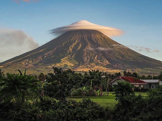
Mayon rises 2,463 metres straight out of flat farmland in Albay, at the southeastern end of Luzon, and is the most active volcano in the Philippines — better than fifty eruptions since the record starts in 1616 — and the one most often called the world’s most symmetrical cone.
The view of Mayon everyone comes for is from the Cagsawa ruins, where a Franciscan belfry stands alone in a field with the volcano squarely behind it; the town around it was destroyed on 1 February 1814 in an eruption that killed around 1,200 people, and a permanent danger zone of six kilometres’ radius rings the summit, which farmers work inside regardless.
The story everyone tells is that Cagsawa church was buried and the belfry is the part that stuck out, but photographs from the 1930s show the tower at much the same height it stands today, which points to a town wrecked rather than entombed — and Mayon’s 1814 ash, thrown a year ahead of Tambora’s, is sometimes named as a contributor to the Year Without a Summer.
4 – Mount Pinatubo

Mount Pinatubo stands in the Zambales Mountains ninety kilometres northwest of Manila and had been quiet for roughly five centuries when it erupted on 15 June 1991 — the second-largest eruption of the twentieth century, and one that coincided with a typhoon crossing Luzon, so the ash fell wet and most of the 847 dead were killed by their own roofs.
What Pinatubo offers now is the crater lake that filled the hole, reached by a long ride up ash-choked riverbeds and a walk at the end; the lahar canyons on the way, cut tens of metres deep into grey debris, give a better sense of the scale than the lake does.
Pinatubo put some seventeen million tonnes of sulphur dioxide into the stratosphere and cooled the whole planet by about half a degree for two years — the cleanest natural experiment in climate forcing anyone has measured — while on the ground it buried the Aeta homelands, finished Clark Air Base and prompted the handover of Subic Bay, ending nearly a century of American basing in the Philippines.
5 – Fort Santiago – Manila
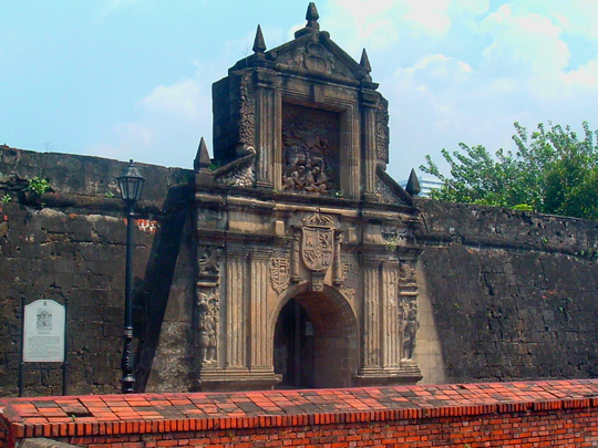
Fort Santiago guards the mouth of the Pasig River inside Intramuros, the walled city the Spanish laid out in Manila from 1571 on ground taken from the Tagalog rulers of Maynila, whose own palisaded fort had stood on the same spot; the stone fortress went up in the 1590s and watched over the Manila galleon trade for three centuries.
Fort Santiago holds the carved gate with its relief of Saint James, walls you can walk, a garden where the moat ran, the cell in which José Rizal spent his last night in December 1896 with brass footprints tracing his walk to the execution ground — and the riverside dungeons, which flooded at high tide and where some six hundred bodies were found when Manila was retaken in 1945.
Rizal wrote his last poem in Fort Santiago that night and hid it inside an alcohol lamp, which he handed to his sister with a whisper that there was something in it; copied out and smuggled abroad, “Mi Último Adiós” did more for the revolution than he managed alive.
6 – Paoay Church
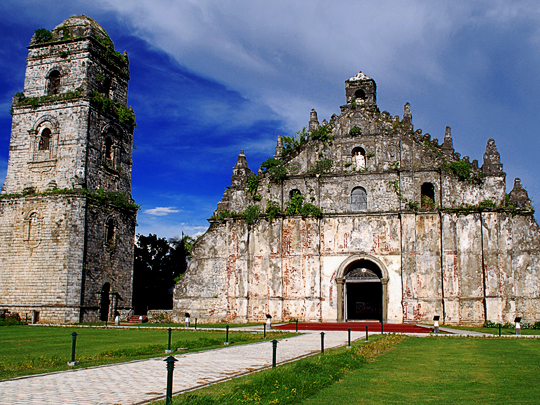
Paoay Church, in Ilocos Norte at the northwestern end of Luzon, was begun in 1694 and finished in 1710, and it is the clearest surviving example of Earthquake Baroque — the Philippine adaptation in which the ornament is structural and the building is designed on the assumption that the ground will move; it is one of four Baroque Churches of the Philippines inscribed together by UNESCO in 1993.
Twenty-four vast buttresses, several with their own staircases, prop the flanks and rear of Paoay Church, which is built of coral blocks below and brick above, bedded in a mortar reported to have been mixed with sugarcane juice, mango leaves and rice straw — and its coral-stone bell tower stands well clear of the building, so that when it falls it falls on nothing.
That detached tower served as a lookout for Filipino revolutionaries against Spain in 1898 and for guerrillas against the Japanese in the 1940s: the feature built to keep Paoay Church safe from earthquakes turned out to be the best observation post in the district.
7 – San Agustín Church – Manila
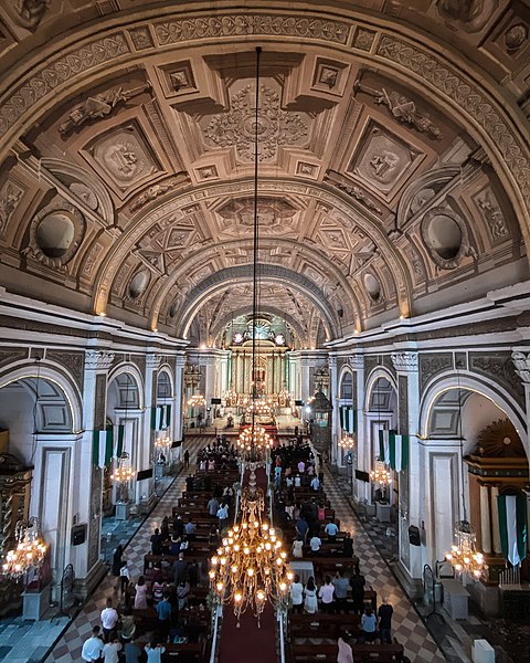
San Agustín in Intramuros is the oldest stone church in the Philippines, completed in 1607, and the oldest of the four Baroque Churches that Paoay also belongs to — it has come through recorded earthquakes in 1645, 1699, 1754, 1796, 1825, 1852, 1863 and 1880, the last of which is why it now has one bell tower where it once had two.
The interior of San Agustín is the surprise: a barrel vault covered end to end in trompe-l’œil painted by two Italian artists in the 1870s, where every coffer, moulding and niche is flat paint, along with carved molave doors, a seventeenth-century choir and a crypt holding Miguel López de Legazpi, who founded Spanish Manila and is buried in the city he took.
In February 1945, Japanese troops held several hundred residents and clergy hostage inside San Agustín through the battle for Manila and many of them were killed; when the shooting stopped it was the only one of Intramuros’s seven churches still standing, in a district that had otherwise been reduced to rubble.
8 – Corregidor Fortress
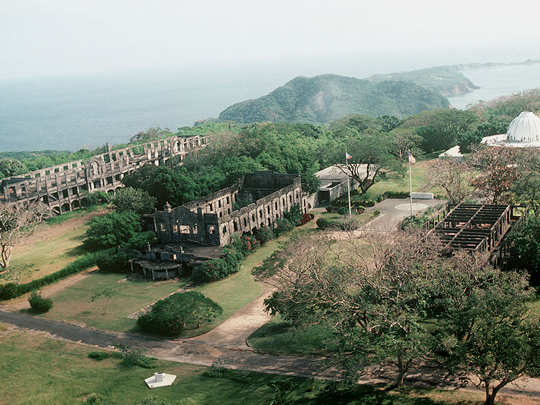
Corregidor is a tadpole-shaped island six and a half kilometres long lying across the mouth of Manila Bay, fortified by the Americans into the strongest position in the Philippines — “the Rock” — and the place the defence of the country came down to once Bataan fell in April 1942.
Corregidor has been left deliberately as a ruin: the shelled Mile-Long Barracks, the gutted cinema and hospital, coastal guns still sitting on their mounts, and the Malinta Tunnel driven through the hill in the early 1930s, which held the headquarters, a hospital and, on 30 December 1941, the second inauguration of President Quezon.
MacArthur left Corregidor by torpedo boat on 11 March 1942 and said “I shall return” once he reached Australia, while the garrison behind him surrendered in early May and went into three years of captivity — and the dome of the island’s Pacific War Memorial is built with an opening aligned so that at noon on the anniversary the sun falls on the altar, marking the surrender rather than the recapture.
9 – Lingayen Gulf
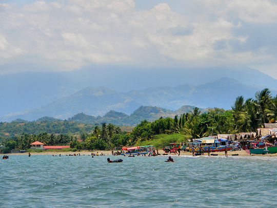
Lingayen Gulf is a wide bay on the northwestern coast of Luzon with a long, shallow, gently shelving shore, which is precisely why two invasions of the Philippines came ashore on the same beaches three years apart, travelling in opposite directions.
What is at Lingayen Gulf now is a long grey-sand public beach with the provincial capitol and the Lingayen Gulf War Memorial behind it and markers along the shore where the landings came in; the Hundred Islands sit at the eastern end of the same gulf, so entries 9 and 11 of this page are the same water.
Homma’s Japanese Fourteenth Army landed at Lingayen Gulf on 22 December 1941 and had Manila within a fortnight; the Americans came back to the same water on 9 January 1945 and put more than two hundred thousand men ashore over the days that followed, under the heaviest concentration of kamikaze attacks of the entire war — roughly four dozen ships struck inside ten days, and on a single morning in early January, twenty-eight aircraft hit fifteen ships.
10 – Coron Island

Coron Island is a wall of black limestone rising 600 metres out of the sea in the Calamian group of northern Palawan, and it is not public land: it belongs to the Tagbanwa, who hold ancestral domain over the island and the water around it — some 22,000 hectares of land and sea claimed in 1998 and formally titled in 2001.
There are twelve freshwater lakes inside the karst of Coron Island and exactly two are open to outsiders — Kayangan, reached over a saddle by a steep stair and startlingly clear, and Barracuda, a dive site where the water gets warmer as you descend, crossing 38°C through a stack of thermoclines, which is the reverse of everything a diver’s body expects.
The other ten lakes on Coron Island are sacred and closed, and the rule is enforced by the Tagbanwa themselves rather than by any park authority — they also harvest swiftlet nests from the cliffs for the Chinese soup trade, which is the other reason the caves here have never been a free-for-all.
11 – Hundred Islands National Park
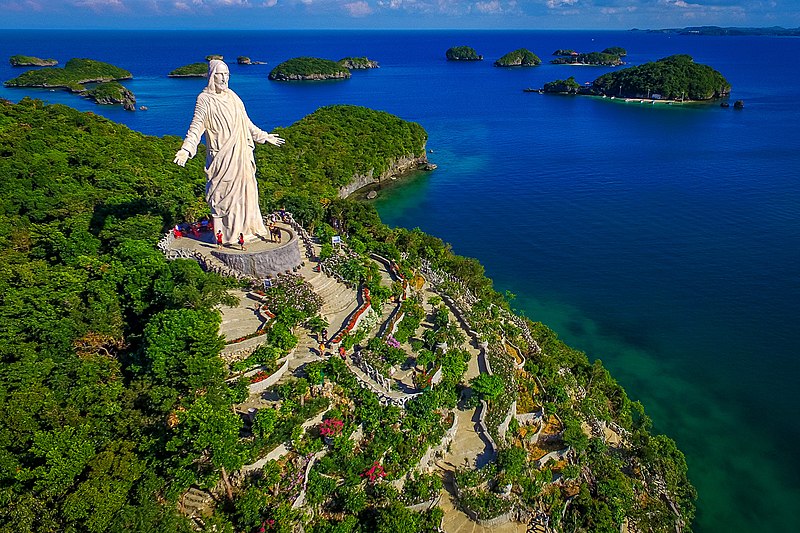
Hundred Islands lies in Lingayen Gulf off Alaminos in Pangasinan, and holds 124 islands at low tide and 123 at high — and it was the first national park the Philippines ever declared, proclaimed by President Manuel Quezon in January 1940.
The islands of Hundred Islands are mushroom-shaped, cut back at the waterline so that each one balances on a stalk narrower than the mass sitting on it, and only four — Quezon, Governor, Children’s and Pilgrimage — are developed for visitors, with boats running out from Lucap wharf and the rest of them left alone.
Every one of those 124 islands is dead coral: the limestone formed underwater as reef, was lifted clear of the sea, and is now being eaten back down by the same water that built it, at an age generally put at around two million years — which makes Hundred Islands a reef caught partway through being handed back.
12 – Banaue
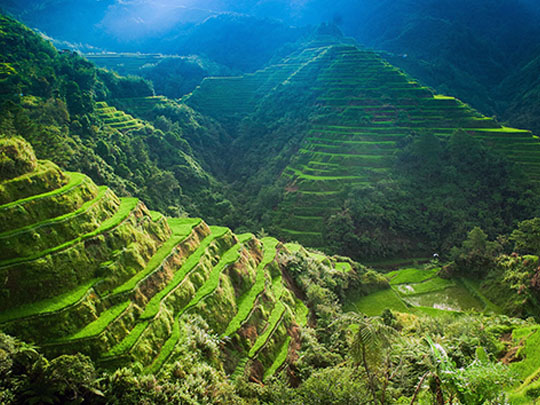

The rice terraces of Ifugao climb the Cordillera of northern Luzon, cut into slopes above a thousand metres and watered from muyong — patches of private forest kept above each cluster to hold the rain, worked under rules older than the Philippine state.
The view most people come to Banaue for is the amphitheatre above the town, a National Cultural Treasure left out of the 1995 UNESCO inscription for holding too many modern buildings; the five inscribed clusters lie further in — Batad and Bangaan above Banaue, plus Mayoyao, Hungduan and Nagacadan — and Batad, reached by road and footpath, is the one wrapping a natural bowl in tiers with walls to head height.
Every sign in Ifugao says the terraces are two thousand years old, a figure traceable to the anthropologist H. Otley Beyer and long fixed in the schoolbooks; excavation has found no rice in the soil before about 1650, pointing to terraces built fast by people moving uphill out of Spanish reach — younger than advertised, and a better story, because it makes them defiance rather than inheritance.
13 – Vigan
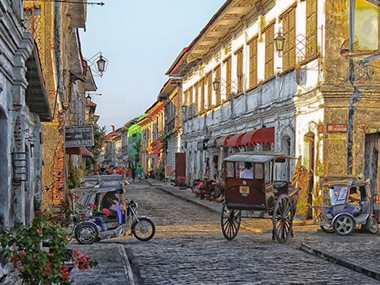
Vigan stands on the coastal plain of Ilocos Sur in northwestern Luzon, once an island between three rivers and a trading port long before the Spanish arrived; Juan de Salcedo founded the town in 1572, and UNESCO, inscribing it in 1999, calls it the most intact planned Spanish colonial town in Asia.
The heart of Vigan is the Mestizo district, and its spine is Calle Crisologo, a cobbled street of bahay na bato — stone and brick below, timber above, sliding windows panelled in capiz shell, deep eaves against the rain — with kalesas working the street, the baroque cathedral and Plaza Salcedo at the end, and potters at Pagburnayan still throwing burnay jars on foot-turned wheels for a dragon kiln.
The most Spanish-looking town in Asia was not built by Spaniards: the merchant houses went up for families of mixed Chinese and Ilocano descent who traded from the ground floor and lived above it, and the hybrid they produced — European street plan, Chinese carpentry, a Filipino answer to heat and rain — is precisely what UNESCO inscribed Vigan for.