

Rod Waddington / Wikimedia Commons / CC-BY-SA-3.0 / GFDL
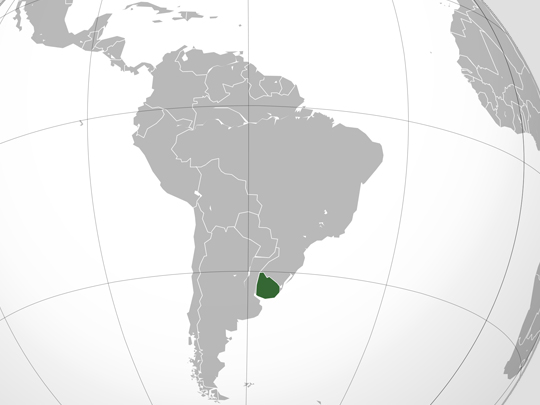
Capital: Montevideo
Population: 3.4 million+
Language: Spanish (Portuñol spoken along the Brazilian border)
1 – Colonia del Sacramento (also above)
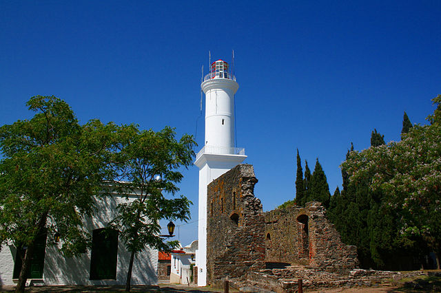
A small city on a peninsula poking into the Río de la Plata roughly 180 km west of Montevideo and directly across the water from Buenos Aires, founded by the Portuguese in 1680 as a base for running contraband into Spanish territory, then fought over for a century and traded back and forth more than ten times before Spain finally kept it.
The Barrio Histórico is a compact grid of cobbled lanes and low stone houses, listed by UNESCO in 1995, with the narrow Calle de los Suspiros, the country’s oldest church, the old city gate and drawbridge, and vintage cars parked outside wine bars.
The century of tug-of-war is still legible in the streets themselves — the Portuguese laid theirs out on an irregular plan with a drain down the middle, the Spanish rebuilt in straight lines with drains at the sides — and the 1857 lighthouse you climb for the view was built straight out of the rubble of a 17th-century convent.
2 – Pocitos
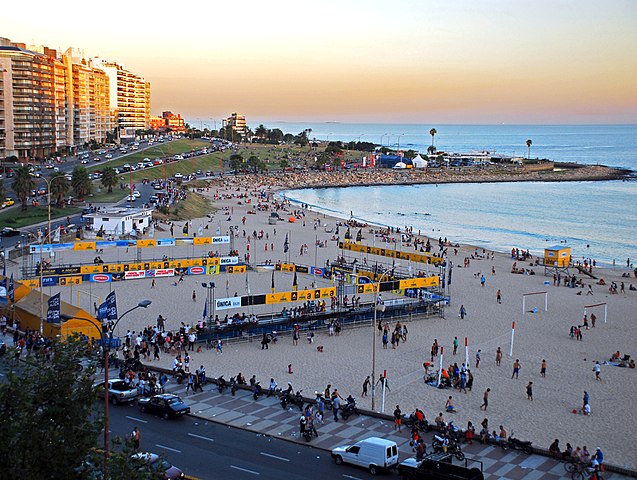
A well-heeled seaside neighbourhood a few kilometres east of central Montevideo, formally founded in 1886 and rebuilt in the 20th century as a wall of apartment towers along the shore; its small local ground, long since gone, staged the very first match of the very first World Cup in July 1930.
The kilometre of pale sand is the city’s most-used beach, backed by the Rambla — a waterfront promenade running some 22 km along the whole coast — and it is the place to see Montevideo at its most ordinary and most pleasant: joggers, thermos flasks of mate, beach volleyball, cafés and parrillas a street back.
The name means “little wells”, after the holes that washerwomen from the walled city used to dig in the sand here to reach clean water, spreading the laundry out to dry on what is now the most expensive beachfront in Uruguay.
3 – Plaza Independencia – Montevideo
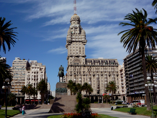
The hinge of Montevideo, laid out where the Spanish citadel once stood and now separating the old town from the modern city, with the 17-metre statue of independence hero José Artigas at its centre and his remains in an underground mausoleum below, watched over by a permanent honour guard.
Around the square stand the Estévez Palace, the Executive Tower, the Solís Theatre and the surviving stone Gateway of the Citadel, while the 26-storey Palacio Salvo of 1928 looms over everything — briefly the tallest building in South America, and now home to a tango museum and a viewing deck.
The Palacio Salvo was built on the site of the Confitería La Giralda, the café where in 1917 a young Uruguayan called Gerardo Matos Rodríguez first had “La Cumparsita” played in public — which means the most famous tango ever written started life on this square.
4 – Port of Punta del Este
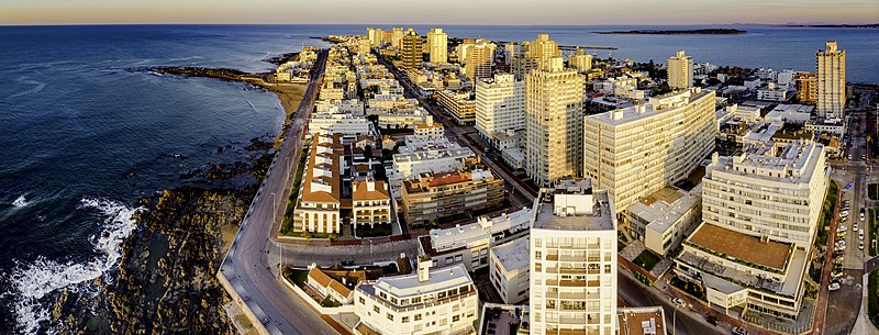
The harbour of Uruguay’s best-known resort, on the narrow peninsula where the Río de la Plata finally gives way to the Atlantic — which is why the town has two quite different coasts, the calm Playa Mansa on the river side and the surf-battered Playa Brava facing the open ocean.
The port is the most enjoyable corner of a glossy town: fishing boats unloading at the quay, seafood restaurants along the front, yachts from Buenos Aires in season, and a permanent gang of sea lions hauled out beside the fish market waiting for scraps.
Round on Playa Brava, five giant concrete fingers rise out of the sand — the 1982 sculpture by Chilean artist Mario Irarrázabal that everyone photographs, and which was never meant as a photo op at all: it was made as a warning to swimmers about the dangerous water behind it.
5 – Cabo Polonio
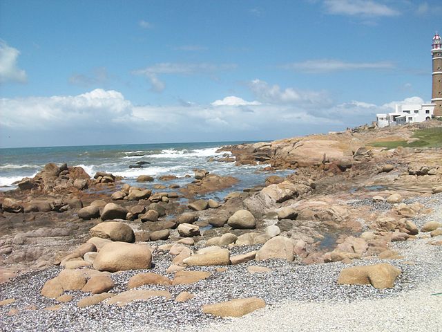
A tiny settlement on a rocky cape on Uruguay’s Atlantic coast in Rocha, marooned behind seven kilometres of shifting dunes, with around a hundred permanent residents; the name is generally traced to a ship lost on these rocks in the 1750s, and a lighthouse was finally built in 1881 to stop it happening again.
No road reaches it, so you leave the car at the park gate and ride in aboard an open-topped 4×4 truck over the dunes and along the beach, then walk everywhere: wooden cabins on sand paths, wild beaches on both sides, a lighthouse you can climb, and hundreds of sea lions sprawled on the rocks below it.
The village runs on solar panels, wind and the odd generator, and the lighthouse is the only building here connected to the national grid — which is why the stars over Cabo Polonio are the ones most Uruguayans have never seen at home.
6 – Estadio Centenario – Montevideo
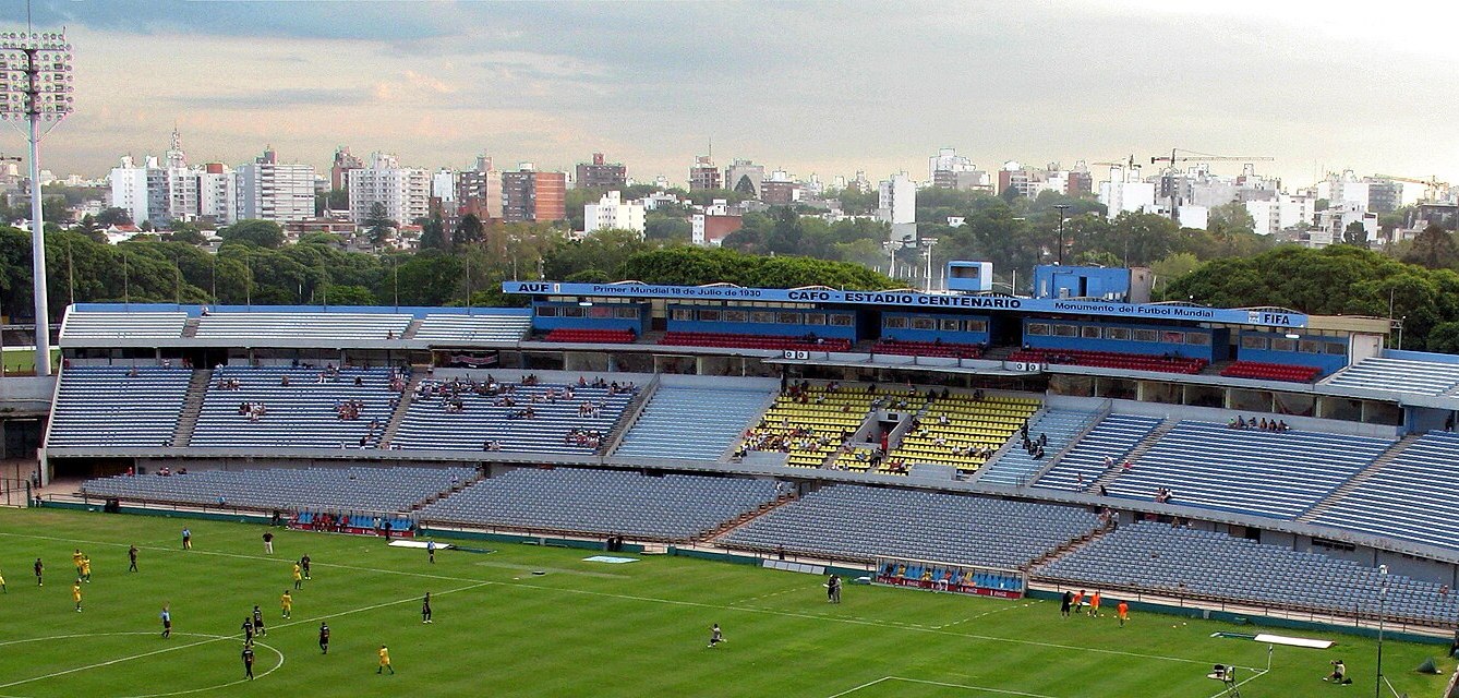
The national stadium of Uruguay, built in a hurry in 1929–30 both for the first ever World Cup and for the centenary of the country’s first constitution, and the ground where the first World Cup final was played on 30 July 1930 — Uruguay beating Argentina 4-2 in front of a packed bowl.
It still hosts the national side and the fierce Peñarol–Nacional derby, and the Museo del Fútbol under the stands holds shirts, trophies and photographs running from the Olympic sides of the 1920s through 1930 and 1950.
FIFA has designated only one building in the world a Historical Monument of World Football, and this is it — though the construction was so tight that 1,100 men working three shifts a day still missed the deadline, and the tournament’s opening matches had to be played at other grounds around Montevideo.
7 – Fray Bentos Industrial Landscape
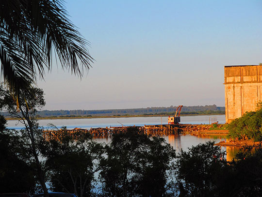
A vast disused meat-processing complex on the Uruguay River in the west of the country, grown from a factory founded in 1859 to turn the cattle of the surrounding grasslands into food for Europe, run first by the Liebig Extract of Meat Company and from 1924 by the British-owned Anglo plant, and listed by UNESCO in 2015.
You tour the works themselves — the enormous cold store, the brick chimney, the machine room, the slaughter floor and the docks — plus the Museum of the Industrial Revolution and the Barrio Anglo, the company town of housing, schools and sports clubs built for a workforce drawn from dozens of countries.
This place called itself the kitchen of the world and meant it: the Oxo cube was developed here, corned beef from these sheds fed the armies of both world wars, and the tinned steak-and-kidney pies still sold in British supermarkets under the name Fray Bentos are named after this Uruguayan river town.
8 – Maldonado
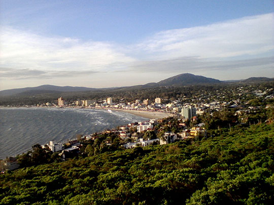
The departmental capital sits a few kilometres inland from Punta del Este and is a great deal older than the resort it now sprawls into, founded in 1755 by the governor of Montevideo to fortify the bay and hold back Portuguese expansion from Brazil, and sacked by British troops in 1806 during their invasions of the Río de la Plata.
The colonial core survives around Plaza San Fernando: the neoclassical cathedral begun in 1801, the stone Dragoons’ Barracks put up between 1771 and 1797 and now a cultural centre, the Torre del Vigía watchtower built to spot ships coming up the estuary, and the Mazzoni museum of local life — all walkable, and all refreshingly free of the crowds a few kilometres south.
Charles Darwin spent ten weeks here in 1833 while the Beagle lay up for repairs, assembling what he considered a nearly complete collection of the district’s birds, animals and reptiles. Isla Gorriti and Isla de Lobos are both off Maldonado, the latter holding one of the largest sea lion colonies in South America under the tallest lighthouse on the continent.
9 – Barrio Sur & Palermo – Montevideo
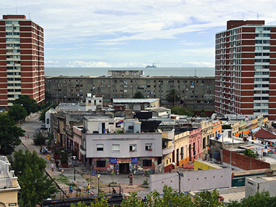
Two adjoining neighbourhoods just south of Montevideo’s centre, where freed and formerly enslaved Africans and their descendants settled around the old shoreline, and where archaeologists have been excavating the Caserío de los Negros, the barracks in which people were held on arrival before being sold — the physical evidence of a trade the city ran for the whole Río de la Plata.
Out of that came candombe: drum ensembles that tune their skins over street fires and then parade the barrios behind the deepest drum, the piano, whose beat differs from one neighbourhood to the next, and which UNESCO placed on the intangible heritage list in 2009.
The February Llamadas parade is the spectacle, but the point of candombe is that it happens on ordinary Sunday evenings all year — you hear the drums a few streets away, follow the noise, and end up walking alongside; local associations run guided visits, which is the right way to do it, since these are homes rather than a heritage site.
10 – Fortaleza de Santa Teresa
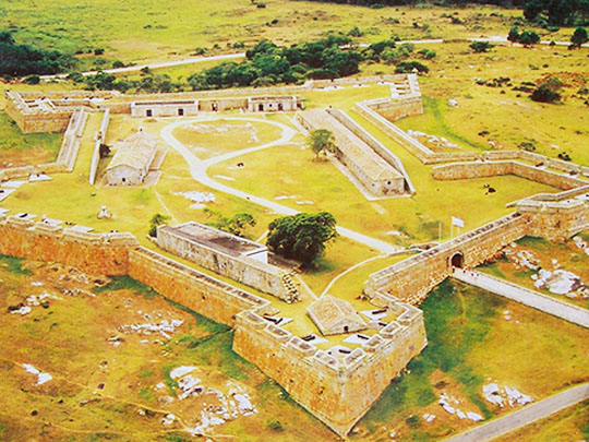

A great pentagonal fortress on a rocky rise near the Atlantic in Rocha, about 300 km north-east of Montevideo, begun by the Portuguese in October 1762 to control the only firm route through the marshes to the sea, and seized within months by a Spanish force under Pedro de Cevallos, who then finished building it himself.
Behind 642 metres of double granite walls you can walk the parade ground, the powder magazine, the chapel, the smithy, the troop quarters and the escape tunnels, with a military museum inside and the beaches, lagoons and vast planted arboretum of Santa Teresa National Park spreading out around it.
It is the physical form of the argument that created Uruguay: Portugal and Spain spent a century shoving each other back and forth across this frontier, and the country that eventually emerged in 1828 was in large part a buffer state agreed between two empires that could not defeat one another here.
11 – Tacuarembó
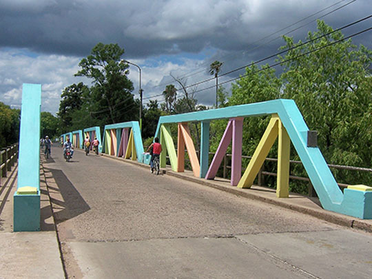
A cattle town some 390 km north of Montevideo in the rolling grassland that covers most of Uruguay, and the accepted capital of gaucho country — the horsemen who worked these plains, fought in the independence wars and became the national figure of a country that is overwhelmingly pasture.
The Museo del Indio y del Gaucho covers both the gauchos and the indigenous peoples who were here before them, the wooded valley of Valle Edén sits half an hour west, and every March the nine-day Fiesta de la Patria Gaucha fills the town with thousands of riders, rodeo, criollo societies competing to rebuild a period ranch in every detail, and a great deal of open-fire cooking.
Valle Edén also has a small museum insisting that Carlos Gardel, the voice of tango, was born on a ranch nearby rather than in Toulouse — a claim most scholars reject and no Uruguayan will let you dismiss.
Hello! My name is Claudio, I am from Uruguay. I have to say that the pics you mentioned in this publication are very clear.
You took some of the best places in my country and the descriptions are perfect! I would like to ad some other places (please I hope this don’t bother you), por example: Punta Caretas neighborhood, Campeón del Siglo Stadium, Legislative Palace.
Please keep going with other places !
Bye!!