
Wikimedia Commons / CC-BY-SA-3.0 / GFDL
Capital: Olympia
Population: 8 million+
Language: English (no official language).

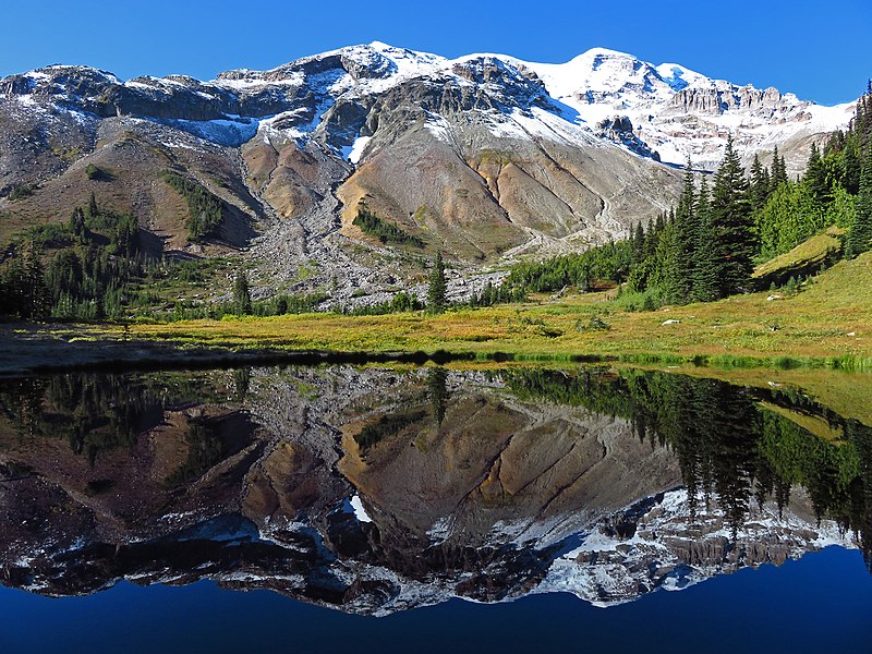
1 – Mount Rainier National Park (also above)

Mount Rainier National Park was created in 1899 as America’s fifth national park, around a volcano of about 14,400 ft that’s the most glaciated peak in the contiguous US, named by George Vancouver in 1792 after his friend Rear Admiral Peter Rainier, who never saw it.
Mount Rainier’s sights include Paradise, with the Paradise Inn of 1917, Sunrise on the mountain’s east side, and the 93-mile Wonderland Trail, which circles the whole peak, while the first recorded ascent was made by Hazard Stevens and P.B. Van Trump in 1870, and John Muir climbed it in 1888.
Paradise set a world record with 1,122 inches of snow in the winter of 1971–72, local tribes knew the mountain by names including Tahoma, and a railroad-backed campaign to rename it “Tacoma” ran into the 1920s, while the UN lists Mount Rainier as a “Decade Volcano” for the danger it poses to the cities around it.
2 – Seattle

Seattle grew from the Denny Party’s landing at Alki Point in a rainstorm in November 1851, it’s named after Chief Si’ahl of the Duwamish and Suquamish, and after the Great Fire of 1889 the city raised its streets, leaving parts of the old town below ground as the Seattle Underground.
Seattle’s sights include the 605-ft Space Needle, built for the 1962 World’s Fair, Pike Place Market, opened in 1907, Kerry Park, with the classic skyline view, and the Burke-Gilman Trail, named after Judge Thomas Burke, son of Irish immigrants and often called “the man who built Seattle”.
Seattle’s Pike Place Starbucks isn’t the first, which opened on Western Avenue in 1971, the famous environmental “Chief Seattle speech” was written by screenwriter Ted Perry in 1972, and the rainy city actually gets less rain a year than New York or Miami.
3 – North Cascades National Park
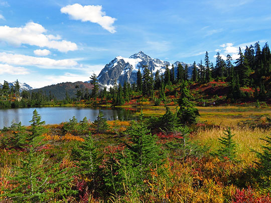
North Cascades National Park, in the rugged northern Cascades along the Canadian border, was created on 2 October 1968 and holds more than 300 glaciers, making it the most heavily glaciated area in the US outside Alaska.
North Cascades’ sights include the North Cascades Highway, opened in 1972 and closed for about 40 miles every winter, turquoise Diablo Lake, coloured by glacial rock flour, Seattle City Light’s dams on the Skagit River, and Stehekin on Lake Chelan, reachable only by boat, floatplane or on foot.
Jack Kerouac spent 63 days as the fire lookout on Desolation Peak in the summer of 1956, which he turned into The Dharma Bums and Desolation Angels, and North Cascades is often listed among the least-visited national parks in the US.
4 – Hurricane Ridge

Hurricane Ridge, in Olympic National Park about 17 miles south of Port Angeles, takes its name from the gales that can blast it at more than 75 mph, and its visitor area sits at 5,242 ft, at the end of a winding road up from the coast.
Hurricane Ridge’s meadows and viewpoints look out across the Olympic Mountains to Mount Olympus, and trails such as Hurricane Hill climb higher along the ridge.
Hurricane Ridge is one of the few ski areas inside a US national park, and its 1952 Day Lodge burned down on 7 May 2023, with no cause ever found.
5 – Myrtle Falls

Myrtle Falls is a 72-ft waterfall on Edith Creek at Paradise, on Mount Rainier’s southern slopes, an area named when a woman of the pioneering Longmire family exclaimed, “Oh, what a paradise!”
Myrtle Falls is about a mile’s round-trip walk on the Skyline Trail from Paradise, accessible to wheelchairs with assistance, and its classic view frames the falls with Mount Rainier’s summit behind.
Mountain guide Jules Stampfler named both Myrtle Falls and Edith Creek in 1907 after women in his climbing parties, and later admitted he couldn’t remember their surnames.
6 – Olympic National Park
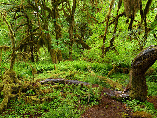
Olympic National Park covers the heart of the Olympic Peninsula, first protected by Theodore Roosevelt as Mount Olympus National Monument in 1909, partly to save the elk already named after him, then made a national park by his cousin Franklin D. Roosevelt in 1938, and it’s a UNESCO World Heritage Site.
Olympic’s sights include the Hoh Rain Forest, often called the wettest forest in the contiguous US, with its Hall of Mosses, glacier-carved Lake Crescent, a wild Pacific coastline, and the Elwha River, where the removal of two dams between 2011 and 2014 was the largest dam removal of its time.
Olympic’s Mount Olympus was named in 1788 by Dublin-born fur trader John Meares, who thought it fit for the gods, and Lake Crescent’s “Lady of the Lake”, barmaid Hallie Illingworth, vanished in 1937 and surfaced three years later, her body preserved like soap by the cold water.
7 – Mount St Helens

Mount St Helens, in southwest Washington, erupted on 18 May 1980, when a magnitude 5.1 earthquake set off the largest landslide in recorded history and a sideways blast that killed 57 people and took about 1,300 ft off the summit.
Mount St Helens National Volcanic Monument, created in 1982, takes in Johnston Ridge, named after volcanologist David Johnston, who radioed “Vancouver! Vancouver! This is it!” to the USGS in Vancouver, Washington, before he was killed, Spirit Lake, once covered by a mat of blasted logs, and Ape Cave, a lava tube about 2.5 miles long, named after a local outdoors club, not Bigfoot.
George Vancouver named Mount St Helens in 1792 after diplomat Alleyne FitzHerbert, who had been Chief Secretary for Ireland and was made Baron St Helens in the Irish peerage in 1791, and 83-year-old lodge owner Harry R. Truman refused to leave the mountain and was never found.
8 – Pacific Crest Trail

The Pacific Crest Trail runs about 2,650 miles from Mexico to Canada, championed from 1932 by Clinton C. Clarke, often called its father, and in 1968 it became one of the first two National Scenic Trails, alongside the Appalachian Trail.
The Pacific Crest Trail’s Washington section, about 500 miles long, starts at the Bridge of the Gods over the Columbia River, crosses the Knife’s Edge in the Goat Rocks, with drops of about 2,000 ft on either side, loops around Glacier Peak and through the North Cascades, and ends at Monument 78 on the Canadian border.
The Pacific Crest Trail’s most famous hiker, Cheryl Strayed, played by Reese Witherspoon in Wild, finished at the Bridge of the Gods, so she never hiked a step of the Washington section.
9 – San Juan Islands
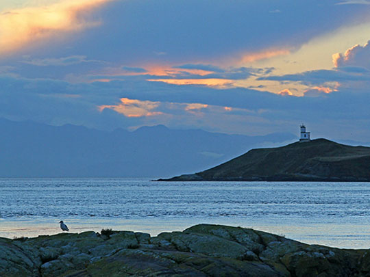
The San Juan Islands, more than 400 islands and rocks between mainland Washington and Canada’s Vancouver Island, were named in 1791 by Spanish explorer Francisco de Eliza, and Orcas Island isn’t named after killer whales but after the viceroy of New Spain, whose name included Horcasitas.
The San Juan Islands have no bridge to the mainland, so it’s a ferry from Anacortes to sights such as San Juan Island National Historical Park’s English Camp and American Camp, and Lime Kiln Point, nicknamed “Whale Watch Park” for the orcas that pass offshore.
The Pig War began on San Juan Island on 15 June 1859, when American settler Lyman Cutlar shot a Hudson’s Bay Company pig from the farm run by Irish-born Charles Griffin, Capt. George Pickett, later of Pickett’s Charge, landed US troops, and Britain’s Rear Admiral Baynes refused to start a war “over a squabble about a pig”, so both sides shared the island until Kaiser Wilhelm I ruled for the US in 1872, without a shot fired between them.
10 – Grand Coulee Dam
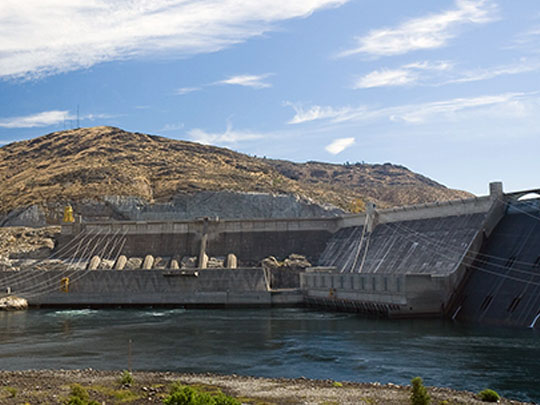
Grand Coulee Dam, on the Columbia River about 90 miles northwest of Spokane, was begun in 1933 as a New Deal project and is the largest hydropower producer in the US, with enough concrete to build a highway from Seattle to Miami, and its power drove aluminium and plutonium production in the Second World War.
Grand Coulee Dam’s sights include Lake Roosevelt, stretching about 150 miles towards Canada, Marcel Breuer’s Brutalist Third Powerplant, the summer laser show projected onto the dam, and the Grand Coulee itself, carved by Ice Age floods, with Dry Falls, about 3.5 miles wide.
Woody Guthrie wrote 26 songs in a month for the project in 1941, including “Roll On, Columbia”, made Washington’s state folk song in 1987, and Lonnie Donegan, whose mother was from Omagh, Co. Tyrone, turned Guthrie’s “Grand Coulee Dam” into a UK skiffle hit in 1958, while the dam, built without fish ladders, ended the salmon runs to the upper Columbia, mourned by the Colville tribes at the Ceremony of Tears in 1940.
11 – Snoqualmie Falls
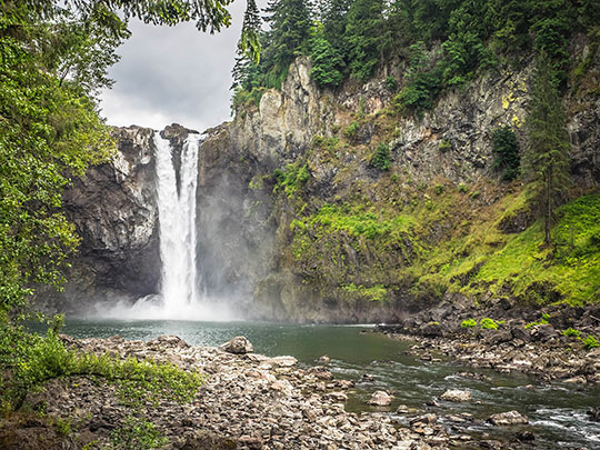
Snoqualmie Falls drops 268 ft on the Snoqualmie River east of Seattle, taller than Niagara though not twice its height as often claimed, and it’s sacred to the Snoqualmie Tribe, who believe First Woman and First Man were created here and that its rising mists carry prayers to the Creator.
Snoqualmie Falls’ sights include the viewpoints above the falls, the Salish Lodge on the clifftop, and Plant 1, built inside the rock beneath the falls in 1898–99 by engineer Charles H. Baker and billed as the world’s first completely underground power plant.
Snoqualmie Falls appears in the opening credits of Twin Peaks, with the Salish Lodge playing the Great Northern Hotel, and in 2019 the Snoqualmie Tribe bought the lodge and 45 acres beside the falls for $125 million, though not the waterfall itself.
12 – Cape Disappointment

Cape Disappointment, at the mouth of the Columbia River in Washington’s southwest corner, was named in 1788 by fur trader John Meares, who missed the river and decided it didn’t exist, until American captain Robert Gray crossed the bar in 1792 and named the Columbia after his ship.
Cape Disappointment State Park’s sights include the Cape Disappointment Lighthouse, first lit in 1856 as the first lighthouse in the Pacific Northwest, North Head Lighthouse, where the wind was clocked at more than 120 mph in 1921, the Lewis and Clark Interpretive Center, and the old Fort Canby gun batteries.
William Clark’s famous “Ocian in view! O! the joy” was written more than 20 miles upriver, where he was really looking at the estuary, though he did reach the cape in November 1805 and carved his name on a tree, and the Columbia Bar offshore, the “Graveyard of the Pacific”, has claimed about 2,000 vessels, which is why the Coast Guard trains its surf-rescue crews here.
13 – Leavenworth
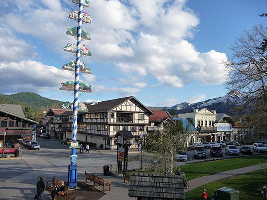
Leavenworth, in the Cascades where Icicle Creek meets the Wenatchee River, was platted in 1893, named after Portland investor Charles Leavenworth, and grew as a Great Northern Railway and sawmill town until both left in the 1920s.
Leavenworth’s sights include the Bavarian-style Front Street, where a design board has enforced the Alpine look since 1970, even on chain stores, the Nutcracker Museum, billed as the largest nutcracker collection in the US, and festivals from Maifest and Oktoberfest to the Christmas Lighting Festival.
Leavenworth has no German roots, as its Bavarian makeover was a 1960s rescue plan, Project LIFE, borrowed from Seattle businessmen Ted Price and Bob Rodgers, whose nearby café had already gone Bavarian, and modelled on the Danish-themed town of Solvang, California.